Welcome to our Community
Wanting to join the rest of our members? Feel free to sign up today.
Sign up

Anafi Thermal/RGB simultaneous imaging

wal

Member
Joined
Feb 17, 2021
Messages
5
Reaction score
1
Does anyone know (or has tested) whether the Anafi thermal can trigger both the thermal and 21MP RGB camera simultaneously? Ideally as part of an automated flight plan. I'm looking at buying the anafi thermal for some agricultural mapping work, but one of my requirements would be that the thermal and RGB cameras can trigger simultaneously - the idea behind this being to make an orthomosaic with the RGB images, but then use this to work out which unstitched thermal images contain the features I'm looking for.

Any help of suggestions appreciated!

Thanks
 
Yes, it takes both an RGB image and Radiometric JPEG.

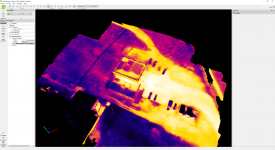
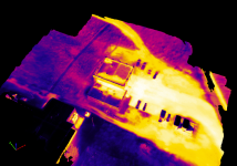
Pix4D does this with the deliverables being Dense Point Cloud and 3D Model/Mesh.

Using Pix4D Capture with the Anafi Thermal you can plan your flight. Circular, Grid, Double Grid, camera angle.

Then process in Pix4Dmapper. It uses the RGB to calibrate and then projects the thermal coloring onto the cloud and mesh.

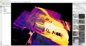
In the Ray Cloud Editor you could then turn on Tie Points and then choose the feature of interest by clicking on it and to the right in the Selection Box it will show the the images for that area.

Example
1616735948155.png

1616736216745.png

I do not think you can make an ortho, only 3D Model, Dense Point Cloud. I have generated an ortho but cannot seem to be able to overlay the thermal data. I will ask Pix4D support and post back.
 
Yes, it takes both an RGB image and Radiometric JPEG....
Fantastic, thanks for the response jaja, very helpful. Just to confirm, the jpegs (visual) that pix4d is using there are the 21mp jpegs and not the visual bands the thermal camera captures? From your post it looks like this anafi thermal will be suitable for the task I have (y)
 
Fantastic, thanks for the response jaja, very helpful. Just to confirm, the jpegs (visual) that pix4d is using there are the 21mp jpegs and not the visual bands the thermal camera captures? From your post it looks like this anafi thermal will be suitable for the task I have (y)

Yes, according to Pix4D it is the RGB images used for calibration and to make the dense cloud. Here is an excerpt from Pix4D.

Note:
  • Initial Processing is done using the RGB camera.
  • The geometry of 3D Textured Mesh and the dense point cloud is derived from the RGB images.
  • The colour and texture of the 3D Texture Mesh and the dense point cloud, respectively, are derived from the thermal camera by projecting the images directly without calibrating them.
Link to Page: How to capture and process data with Parrot ANAFI Thermal

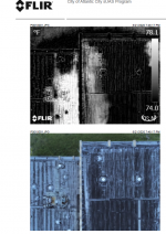
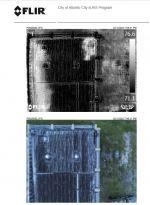
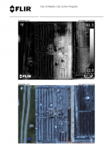
And this process is pretty accurate so far. I've only run one dataset but the warm anomalies on the low sloped roof match very well with the normal roof moisture scan I've done following best industry practices (Minus using a thermal imager with such low resolution).

Here is the roof moisture scan tuned in Flir Tools. Notice both the higher and lower roofs warm anomalies match up very well in the model and the Flir Tools outputs.

1616974062820.png

1616974086928.png
1616974130117.png
1616974188494.png
 
  • Like
Reactions: wal
Thanks for the explanations.
However, on my side, I Keep failing. Using the Pix4DCapture, choosing the Anafi Thermal RGB, It only takes RGB pictures. I tried to trick it, by choosing the Anafi-Thermal drone, but then this is only a very blurred thermal pictured which is taken. What am I missing ? Once on Anafi Thernal RGB, it should take both of them no? I am bit confused.
Thanks in advance
Best
Emmanuel
 
When you define the flight plan in Pix4D Capture you must have already set the drone to Anafi Thermal and then go into the settings and choose Thermal camera. Keep in mind the GSD is for the RGB camera though.
 
When you define the flight plan in Pix4D Capture you must have already set the drone to Anafi Thermal and then go into the settings and choose Thermal camera. Keep in mind the GSD is for the RGB camera though.
Thanks for your answer. I can only choose the drone not the camera. In settings, I do not have any camera choice..
 
Are you using iOS or Android. I use iOS so there may be a difference is how you choose the thermal camera in Pix4DCapture. I will try to use Android and see how it works.
 
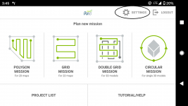
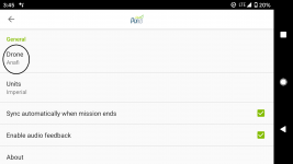
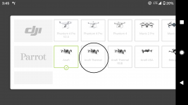
Okay I just opened up Pix4D Capture on an Android device. It has changed since the last time I used Android as I use my iPad.

Here is the sequence.

1618084418420.png
1618084450233.png

1618084490336.png


I assume this is what you did? In iOS there is not only choose your drone, but choose your camera where you can choose the thermal or 4K.
You would think that with Android when you choose Anafi Thermal it is for the thermal camera only. If I get a chance I will test my Anafi Thermal with Android and see if my results are thermal images.

Something really concerning though is that for Android, Pix4D Capture has really taken away a lot of functionality since I last used it. You can no longer set over lap both side and front, only a simple high or low.
Also I will be making a new thread on Pix4D Capture, as I used both iOS and Android the other day and now instead of using the 21 MP images it has the camera take the 16MP rectilinear images, and these do not calibrate correctly in Pix4D Mapper, Reality Capture or Drone Deploy.
Talk about taking something that works and make it not work.
 

Members online

No members online now.

Forum statistics

Threads
5,307
Messages
45,090
Members
8,004
Latest member
gearsgood