Welcome to our Community
Wanting to join the rest of our members? Feel free to sign up today.
Sign up

Anafi para mapear... consulta

Nahuel

New member
Joined
Aug 8, 2019
Messages
4
Reaction score
1
Hala, mi nombre es Nahuel, soy de Argentina.
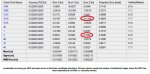
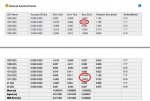
Trabajo en Agrimensura y Topografía, y hemos adquirido un Anafi Work, el cual hemos esado probando para ver los resultados que pueden obtener tanto en planimetria (Coordenadas X, Y) como en altimetria (Coordenada Z).

Teniamos temor, ya que la deformación del lente es importante para este tipo de trabajos.
Los resultados que obtuvimos en X, Y fueron buenos, pero en Z tuvimos algunos problemas, ya que hemos tenido diferencias de más de 10 cm en algunos sectores (principalmente en zonas donde se produjeron desniveles). (las pruebas se realizan con vuelos de 45 m de altura)

Mi consulta es ¿alguien tiene experiencia de este tipo de trabajos con este equipo? ¿Qué resultados han obtenido? ¿Es confiable este equipo para trabajar en topografía?

desde ya les agradezco.
 
Translation because why not

Hala, my name is Nahuel, I'm from Argentina.
I work in Surveying and Surveying, and we have acquired an Anafi Work, which we have been testing to see the results that can be obtained both in planimetry (Coordinates X, Y) and altimetry (Coordinate Z).

We were afraid, since the deformation of the lens is important for this type of work.
The results we obtained in X, Y were good, but in Z we had some problems, since we had differences of more than 10 cm in some sectors (mainly in areas where there were unevennesses). (the tests are carried out with 45 m high flights)

My question is: does anyone have experience of this type of work with this team? What results have you obtained? Is this equipment reliable to work in topography?

I thank you in advance.

I’ve done some basic photogrammetry with a disco, but nothing detailed requiring the exacting stuff it sounds like he wants to do.

I expect this type of detail work is more often done with lidar, but they are generally heavy and expensive.

Getting better than 10cm tolerance in the vertical seems optimistic, but with this sort of thing you can get better accuracy with more overlapping photos, and better processing of the photos.

Many services and software also support adding targets into your survey area, which you precisely measure then can be used to “pin your work surface” to in the software/service. With points that are known in 3d space it makes it much easier to stitch together the rest well.

If you’re just looking for examples other people have, then I’ll perhaps let others chine in ( my wife has all the real GIS training, I’m really an amateur here ).

If it’s actual questions about the results you have and what can be done to improve them, I would probably start with describing how photos are currently processed, and some examples of where things appear to have gone awry.
 
  • Like
Reactions: Nahuel
Yo tengo experiencia en este tipo de fotogrametría. En mi caso, yo utilizo un Phantom 4 Pro y el margen de error ha sido alrededor de 3-5cm. Es bien importante que tengas 3 puntos de elevacion y coordenadas para utilizar como referencia. Al hacer el foto montaje, entras estas referencias y el dibujo esta supuesto a corregirse. Trabajando para una compañía de ingeniería, puedo utilizar el producto final de mi vuelo para sacar cantidades y exportarlo a Civil 3D.

@AugerIn basicamente dice lo mismo que yo. Es bien importante que tengas un overlay de 80-90% para tener mas definicion y precision en tu dibujo. Otra cosa bien importante que vas a necesitar es una computadora que tenga mucho ram, una excelente tarjeta de video y un buen procesador. Otra opcion es usar los servicios de compañias que te hacen el trabajo a traves de la web.

I have experience in this type of photogrammetry. In my case, I use a Phantom 4 Pro and the margin of error has been around 3-5cm. It is very important that you have 3 elevation points and coordinates to use as a reference. When making the photo montage, you enter these references and the drawing is supposed to be corrected. Working for an engineering company, I can use the final product of my flight to get quantities and export it to Civil 3D.

@AugerIn basically says the same as me. It is very important that you have an overlay of 80-90% to have more definition and precision in your drawing. Another very important thing that you will need is a computer that has a lot of ram, an excellent video card and a good processor. Another option is to use the services of companies that make you work through the web.
 
  • Like
Reactions: Nahuel
Gracias por las respuestas.

Nosotros nos dedicamos a esto, ya hemos realizado fotogrametria con otro equipo (eBee RTK) y hemos obtenido excelentes resultados.

Adquirimos este equipo y como las pruebas no nos han dado como lo esperábamos, entonces estoy buscando a ver si alguien puede ayudarme.

Hicimos un relevamiento de 2.5 Hectareas, donde colocamos 13 GCPs medidos con GPS (de precisión), los cuales utilizamos para ajustar el modelo, y además medimos una gran cantidad de Check Point para controlar los resultados (algunos sobre terreno natural, veredas, etc... y otros con marcas que colocamos nosotros pero que no utilizamos para ajustar solo para control).
El Pos-proceso lo realizamos con el software pix4d. Como resultado obtuvimos un GSD de 1,77 cm, por lo cual entendemos que las precisiones deberian rondar los 3.54cm en X,Y, y 5.31 en Z.

Adjunto un par de capturas del informe de calidad de pix4d, donde se pueden observar los resultados en los GCPs y también de los Check Point. Ya aquí se pueden ver algunos puntos que están fuera de la tolerancia, y casualmente se encuentran ubicados en sectores elevados 1 metro del resto, aproximadamente, tampoco el desnivel es tan grande. Y esto es lo que nos resulta extraño, que en en los sectores llanos, los resultados son mejores.

Nuestra duda es si el ANAFI es un equipo apto para realizar fotogrametria con buenas precisiones. Por eso queria saber si alguien tuvo experiencia con este equipo realizando este tipo de trabajos.
 

Attachments

  • control 2.jpg
    control 2.jpg
    110.3 KB · Views: 6
  • paf.jpg
    paf.jpg
    115 KB · Views: 6
Last edited:
Gracias por las respuestas.

Nosotros nos dedicamos a esto, ya hemos realizado fotogrametria con otro equipo (eBee RTK) y hemos obtenido excelentes resultados.

Adquirimos este equipo y como las pruebas no nos han dado como lo esperábamos, entonces estoy buscando a ver si alguien puede ayudarme.

Hicimos un relevamiento de 2.5 Hectareas, donde colocamos 13 GCPs medidos con GPS (de precisión), los cuales utilizamos para ajustar el modelo, y además medimos una gran cantidad de Check Point para controlar los resultados (algunos sobre terreno natural, veredas, etc... y otros con marcas que colocamos nosotros pero que no utilizamos para ajustar solo para control).
El Pos-proceso lo realizamos con el software pix4d. Como resultado obtuvimos un GSD de 1,77 cm, por lo cual entendemos que las precisiones deberian rondar los 3.54cm en X,Y, y 5.31 en Z.

Adjunto un par de capturas del informe de calidad de pix4d, donde se pueden observar los resultados en los GCPs y también de los Check Point. Ya aquí se pueden ver algunos puntos que están fuera de la tolerancia, y casualmente se encuentran ubicados en sectores elevados 1 metro del resto, aproximadamente, tampoco el desnivel es tan grande. Y esto es lo que nos resulta extraño, que en en los sectores llanos, los resultados tienden a mejorar.
Tienes que recordar que el Parrot Anafi no es RTK, por lo cual tiene un margen de error de aproximadamente .1+/- metros. Para medidas mas precisas necesitas un modelo RTK como el Ebee que mencionas, un D-RTK station y/o Propeller Aeropoints. Si el servicio que ofreces es agrimensura, vas a necesitar todo ese hardware para poder hacer un rendimiento preciso de la topografia. En mi caso, no tengo que ser tan preciso y conociendo el margen de error, lo tomo en consideración y añado por encima de lo que me indica.


You have to remember that the Parrot Anafi is not RTK, so it has a margin of error of approximately .1 +/- meters. For more precise measurements you need an RTK model like the Ebee you mention, a D-RTK station and / or Propeller Aeropoints. If the service you offer is surveying, you will need all that hardware to be able to perform accurate topography performance. In my case, I don't have to be so precise and knowing the margin of error, I take it into consideration and add above what it tells me. (This was translated by Google Translate. I was too lazy to rewrite everything in english, so there are some errors)
 
Last edited:
Tienes que recordar que el Parrot Anafi no es RTK, por lo cual tiene un margen de error de aproximadamente .1+/- metros. Para medidas mas precisas necesitas un modelo RTK como el Ebee que mencionas, un D-RTK station y/o Propeller Aeropoints. Si el servicio que ofreces es agrimensura, vas a necesitar todo ese hardware para poder hacer un rendimiento preciso de la topografia. En mi caso, no tengo que ser tan preciso y conociendo el margen de error, lo tomo en consideración y añado por encima de lo que me indica.


You have to remember that the Parrot Anafi is not RTK, so it has a margin of error of approximately .1 +/- meters. For more precise measurements you need an RTK model like the Ebee you mention, a D-RTK station and / or Propeller Aeropoints. If the service you offer is surveying, you will need all that hardware to be able to perform accurate topography performance. In my case, I don't have to be so precise and knowing the margin of error, I take it into consideration and add above what it tells me. (This was translated by Google Translate. I was too lazy to rewrite everything in english, so there are some errors)

Gracias por tu comentario.

Si si, tenemos en cuenta que no es RTK el AParrot Anafi. Por ese motivo trabajamos utilizando tantos GCP, para poder ajustar el modelo. Cuando trabajamos con el eBee los GCP no han sido necesarios para ajustar, si los hemos utlizado como control.
Pero por ejemplo, Phantom 4 no tiene RTK, pero si se obtienen buenas precisiones, y esas son las que buscamos en Parrot Anafi, pero hasta el momento no las hemos conseguido.
 
  • Like
Reactions: Ansia
Gracias por tu comentario.

Si si, tenemos en cuenta que no es RTK el AParrot Anafi. Por ese motivo trabajamos utilizando tantos GCP, para poder ajustar el modelo. Cuando trabajamos con el eBee los GCP no han sido necesarios para ajustar, si los hemos utlizado como control.
Pero por ejemplo, Phantom 4 no tiene RTK, pero si se obtienen buenas precisiones, y esas son las que buscamos en Parrot Anafi, pero hasta el momento no las hemos conseguido.
Recuerda que cuando tomas una foto en movimiento, crea distorción. El Phantom 4 Pro tiene un obturador mecánico, eliminando esta distorción. Con todo y eso, tiene un margen de error aprox 5cm. A mi entender es el único drone que lo tiene. Es una lastima que DJI descontinuara el Phantom a favor del Mavic...

Remember that when you take a photo in motion, it creates distortion. The Phantom 4 Pro has a mechanical shutter, eliminating this distortion. With everything and that, it has a margin of error approx 5cm. In my opinion it is the only drone that has it. It's a shame that DJI discontinued the Phantom in favor of the Mavic ...
 

Members online

No members online now.

Forum statistics

Threads
5,305
Messages
45,087
Members
8,002
Latest member
lustar