Hi

No problem, it's been a while I wanted to going back here, in this discussion thread!
- Part I: let's reply to the 5 questions
- Part II: my test flight and the results
- Part III: photography in planned mission
Part I: let's reply to the 5 questions
- At the first configuration it asks me which protocol to use, PX4 or Mavlink. Mavlink right?
It seems that we can use
PX4 Pro firmware (that's the choice I have done), but I can experiment
Mavlink Generic... asap!
(the first message in QGC said:
"If you are unsure of the correct values leave them as is.")
As you can see bellow, it worked fine for my test flight.
- Once connected, do I have to perform some kind of calibration or parameter adjustment in the software or do I leave everything as it is?
Except the step to choice the firmware, I made some minor changes in Application Settings (Video Settings, Default Mission Altitude, etc.), and also in
Vehicle Setup > Radio for joystick (= the controller) configuration.
But I was surprised by the quick start of this tool
") - How should the controller be connected to the pc? with a usb A to usb A male cable?
- How should the controller be connected to the pc? with a usb A to usb A male cable?
It's the same cable as for the charge of the radio: USB-C (Skycontroller) to USB-A (PC).
- If I use the wifi connection to contact the drone, I cannot use the connection to load maps. Is there any solution?
I have the same problem... For my test flight (not connected to the web), the map was in cache and QGroundControl loaded from this.
For me, it was not a "real" problem, the mission was successfully done with the map cache. But you must prepared your mission before the outdoor flying.
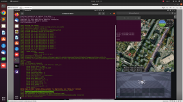
- Have you tried uploading a mission? Works well?
Yes, it's works! Let's rock, back to 2021: (see bellow)
Part II: my test flight and the results
Short video here ->>
2021.09.03_Chapelle_Hochstett.mp4 <<-

And now, the results:
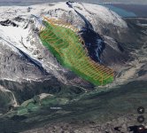
1st passage with flight plan prepared with
PIX4Dcapture:
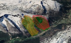
2nd passage with flight plan prepared with
QGroundControl:
Part III: photography in planned mission
Photography... but Photogrammetry in fact!
As you can see on the video, I made a survey "
double grid" mission, for 2D/3D render (orthophoto and model). The altitude was fixed at 30m (by me) to prepare another flight for my job. But here, 15m would have been enough...
_ Overlap in PIX4Dcapture: 80% (no other option)
_ Overlap in QGroundControl: 80% (Front Lap) and 75% (Side Lap)
First of all, I found QGroundControl much more practical and technical than PIX4Dcapture. But if you want a quick mission planning ("à l'arrache", comme on dit), PIX4Dcapture may be a good solution to start. Note there is a smartphone version of QGroundControl, here:
download_and_install -> android
Secondly, I'm a little annoyed because neither of these two software allows you to take WIDE (JPG or RAW) photos, here is why it can be embarrassing:
For photogrammetry processing, the photos must be as "pure" as possible. No correction, no cropping, ...
NO RECTILINEAR. The WIDE format is the best choice for avoid problems in calibration process. RAW or JPG, no matter.
Now, look at this interview:
Parrot : questions et réponses avec Cécilia Hage et Martin Liné | p3
At the question:
Pourquoi n’y a-t-il plus de stabilisation quand on est en mode photo ? Martin Liné explains why WIDE photo is only stabilized on 2-axis_mechanical, and the RECT stabilized on 5-axis (2-axis_mechanical + 3-axis_electronic). It's good to know that.
Finaly, how can we take photos in WIDE mode, during a planned mission?
_ First option (not a real solution):
Gaël Billon offers a solution to bypass the limitation of PIX4Dcapture:
Shooting in RAW (DNG) with the Parrot Anafi and Pix4D Capture
Also in french:
Prendre des photos en DNG (RAW) avec le Parrot Anafi et Pix4D Capture
_ Second option (must be worked to be a good solution):
Alex "adsnash" comes with his converter, hosted in GitHub:
Flightplan Converter
He writes an entry also here:
Sphinx Bugs and Flightplan Issues
This second option is very interesting: the tools generate a .txt file in
QGC WPL 120 format which respects the WP defined by QGC and imposes a "breaktime" on each WP. More options are available, including the ability to take photos in JPEG RECT or WIDE, and also RAW.
"
But ESPARUS ONLINE also allows you to choose the type of photo!"
Yes, i heard you. But we can't planned a double (or simple) grid for cartography mission, for example...
So, I have a question for
@abant:
Is there a way to convert/adapt the
QGC WPL 120 format to load it in FreeFlight 6 (in-app) FlightPlan?
Thank you for your attention.
It was a bit long, but I really enjoyed writing this post!

Thanks to those who were patient enough to read it until the end.


 github.com