
- Joined
- Jul 18, 2026
- Messages
- 4
- Reaction score
- 0
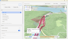
Hi all — I maintain a free, open-source (MIT) tool that reads the telemetry drones embed in their footage and produces flight maps, GPX/CSV/KML exports, and sun-position verification for georeferencing. The good news for Anafi owners: ExifTool already decodes Parrot's embedded video metadata (GPS, altitude, attitude, camera settings — the com.parrot.videometadata streams from Parrot's own PDrAW spec), so wiring it up is a small change. I just need real footage to build and verify against.
The ask: a 10–20 second unedited clip straight off the SD card from any Anafi (original, USA, Ai). It must be the original file — YouTube re-uploads and edited exports strip the metadata. Any file-share link works.
On privacy: the clip contains your flight's GPS track, so fly somewhere unremarkable if you prefer — coordinates are anonymised (~100 m) before anything becomes a public test file. Contributors get credited in the release notes unless you'd rather not be. You can share via DM or marcus/@/callmarcus.com
Result: convert gpx, flight maps, and sun/shadow verification working on Anafi footage out of the box. The project is "dji-drone-metadata-embedder" on GitHub — no ads, no telemetry, no paid anything
The ask: a 10–20 second unedited clip straight off the SD card from any Anafi (original, USA, Ai). It must be the original file — YouTube re-uploads and edited exports strip the metadata. Any file-share link works.
On privacy: the clip contains your flight's GPS track, so fly somewhere unremarkable if you prefer — coordinates are anonymised (~100 m) before anything becomes a public test file. Contributors get credited in the release notes unless you'd rather not be. You can share via DM or marcus/@/callmarcus.com
Result: convert gpx, flight maps, and sun/shadow verification working on Anafi footage out of the box. The project is "dji-drone-metadata-embedder" on GitHub — no ads, no telemetry, no paid anything