Welcome to our Community
Wanting to join the rest of our members? Feel free to sign up today.
Sign up

GPS accuracy of parrot anafi

mawin9587

Member
Joined
May 20, 2022
Messages
6
Reaction score
0
It seem my parrot anafi move to target lat,long with 2 - 3 meters error, is this normal? My anafi be able to receive up to 17 satellites
 
Hello,

The ANAFI has a commercial grade GPS, where up to 3 m deviation isn’t uncommon. According to the spec in the white paper on page 10, it should be “1.2m standard deviation”. In real life this accuracy will depend on many factors, especially if you are on the ground near cliffs or tall buildings etc that can affect the signal from the satellites.

Edit: This link gives a few clues to how GPS works and what impacts accuracy:

Note that signals from satellites are aimed to be equal or less than 2m (but typically less). A device can’t be more accurate than the signal, unless you go for a high end solution using RTK / PPK technology.
 

Attachments

  • B7F5228F-DF6C-4517-B9C6-B8DE60EB8747.jpeg
    B7F5228F-DF6C-4517-B9C6-B8DE60EB8747.jpeg
    312.2 KB · Views: 4
  • D1C7C1E5-DA9D-4D32-AF21-5000A26EB44C.jpeg
    D1C7C1E5-DA9D-4D32-AF21-5000A26EB44C.jpeg
    401.5 KB · Views: 3
Last edited:
  • Like
Reactions: BRC and Skydreamer
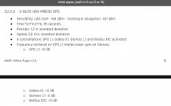
Superb reply sir, thank you very much, PPK/RTK is what I need. Unfortunately, I have no any knowledge about this, if I need to apply them with my parrot anafi, what should I do, if you can guide me or any suggestions are welcome, In the meantime, I'm go studying of it, thank you so much again sir.
 
I'm coding with parrot anafi via its own SDK (Olympe - Python controller library) but the main problem is too inaccurate GPS that I mentioned above, i just need to improve its accuracy to be less than 10 cm. if its possible, so your reply before is very clear for the first questions, now I just need to figure out the way to apply RTK, but for now, I'm not sure about what sensors, controller, any equipment require for that.
 
In that case, I don’t think RTK/PPK is the solution for you, as these correction techniques applies mostly for photo-position for more accurate drone mapping, and require drones that are compatible with the technology. The Anafi is not.

It is also very expensive and require a base station in addition to the drone.

For that kind of precision, I would suggest relying the downward facing camera - I.e. having a ground that is easy for the drone to navigate visually.

I’m not an expert though, the people at the Parrot developer forum might be more helpful.
 
you are right, thank you for your very helpful reply.
P.S. this forum is more active about 10 times compare to Parrot developer forum.
 
you are right, thank you for your very helpful reply.
P.S. this forum is more active about 10 times compare to Parrot developer forum.
I’ve noticed the same.. the other forum is a bit hit and miss. Sometimes you get a clear reply very fast, but most times it seems dead, sadly.
 

New Posts

Members online

No members online now.

Forum statistics

Threads
5,295
Messages
45,052
Members
7,965
Latest member
Peanut