Welcome to our Community
Wanting to join the rest of our members? Feel free to sign up today.
Sign up

ANAFI LOST IN TREES!!!!

Benshearer

Member
Joined
Jul 21, 2019
Messages
7
Reaction score
0
Evening all

So my brother purchased a Parrot Anafi Wednesday and he has been piloting it ever since.

Yesterday morning he took it out for a fly when the low battery indicator flashed up to advise the drone would RTH in 2 minutes. Rather than risk it he hit the RTH button and waited for the return, but it decided it wanted to start a descend early.

My brother has panicked and started running to where the drone was coming down which was on top of a small forest type environment. The drone has landed in the trees with an absolutely depleted battery!

We have spent 2 days trying to find the drone but we have had no luck. How accurate is the GPS on these things?

We have the drone location on the map and when we are near the location on the controller the GPS skips slightly around the spot.

We have run out of ideas. It is fairly dense and the trees are at least 30ft, although the last photo we got from the camera we believe the drone is lower than the very top of the trees.

Has anyone else experienced these random landings rather than the backup RTH function kicking it?

It also says it is 0m about ground but I am not sure that is correct.
 

Attachments

  • Screenshot_20190721-222904_WhatsApp.jpg
    Screenshot_20190721-222904_WhatsApp.jpg
    1.1 MB · Views: 50
  • Screenshot_20190721-222854_WhatsApp.jpg
    Screenshot_20190721-222854_WhatsApp.jpg
    1.1 MB · Views: 50
We have climbed as high as we can get, even shook the trees with a few of us at the bottom ready to catch, and cut obstructing branches but no joy!

I didn't know if there may have been some expected radius the GPS works within so we was thinking of expanding the search are but it really is a needle in a hay stack if we had to!
 
Hopful it's not a well traveled area I would keep looking, and if there is a wind storm it will come down look 50 foot around area from gps
 
  • Like
Reactions: Benshearer
Evening all

So my brother purchased a Parrot Anafi Wednesday and he has been piloting it ever since.

Yesterday morning he took it out for a fly when the low battery indicator flashed up to advise the drone would RTH in 2 minutes. Rather than risk it he hit the RTH button and waited for the return, but it decided it wanted to start a descend early.

My brother has panicked and started running to where the drone was coming down which was on top of a small forest type environment. The drone has landed in the trees with an absolutely depleted battery!

We have spent 2 days trying to find the drone but we have had no luck. How accurate is the GPS on these things?

We have the drone location on the map and when we are near the location on the controller the GPS skips slightly around the spot.

We have run out of ideas. It is fairly dense and the trees are at least 30ft, although the last photo we got from the camera we believe the drone is lower than the very top of the trees.

Has anyone else experienced these random landings rather than the backup RTH function kicking it?

It also says it is 0m about ground but I am not sure that is correct.

Under poor reception conditions between the trees, you should count on a GPS accuracy of + - 10-15 meters.

If Anafi was less than 25 meters from where the takeoff was, Anafi will land on the spot where it is instead of performing an RTH. Couldn't that be what happened ?

Maybe the RTH height was set at 20 meters and the trees are higher ?

In any case, the LAND and RTH commands can be interrupted by using a stick up.

It is stupid to fly so low among the trees if you do not know what you are doing as it is easy to lose the connection between the controller and Anafi.

Remember to recharge the battery as soon as it finds Anafi so it does not take more damage.

Hope you find Anafi undamaged.

Bedst regards, Leif.
 
  • Like
Reactions: Benshearer
If you do find it, never, ever let the battery get that low before flying back to you or using RTH. Experienced fliers never go below 20% if the drone is far away, and 15% if it is within 100 feet. The readout is not super accurate and some have reported the drone going into RTH with 15% still showing.

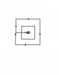
Regarding finding it, you need to use a precise search pattern like SAR people use. Go to the co-ordinates where the GPS says it is. Walk 5 paces in any cardinal direction, turn 90 degrees and walk 5 paces in the new direction. Then turn another 90 degrees and now walk 10 paces. Turn 90 degrees and walk 10 paces again. Repeat. For the last leg to close the square walk 5 paces in the second direction. Return to the original position, which of course you marked. Now walk 10 paces first and second, 20 paces third fourth and fifth directions and 10 paces back to the position 10 paces in the original direction from the origin. You will now have traced out two squares, the second twice the size of the first. All the lines of the first square will be from 5 paces to perhaps 7 paces from the origin. All the lines of the larger square will be from 10 paces to 13 paces from the origin. Repeat at 30 paces if necessary.

Square.jpg

Take a rope and compass with you. Stop at every tree as you go around this imaginary square, attach the rope as high as you can reach and both pull like hell and let go. Repeat and see if you can get a rhythm going. The object is to shake the drone loose AND/OR to get the branches moving so perhaps you can see it. This could be a team effort: one guy paces and keeps track of exactly how many when you stop to wiggle a tree, two guys to attach and pull the rope and one other to stand a few feet away, perhaps circling the tree as you wiggle it. Or even more neighborhood kids....in this case you can't really have too many eyes trying to catch a glimpse of a part of the drone, but they all have to be spaced about the same distance apart.

I did SAR about 50 years ago and this is exactly what I would do if I lost my drone in a forest. If nothing shows up, I would move the point of origin so that the next iteration is right next to, but not overlapping, the first attempt. Time consuming? You bet! But a logical pattern will give the best chance of locating it, and the square is much easier than a circle to keep accurate.

Good Luck!!!
 
Evening all

So my brother purchased a Parrot Anafi Wednesday and he has been piloting it ever since.

Yesterday morning he took it out for a fly when the low battery indicator flashed up to advise the drone would RTH in 2 minutes. Rather than risk it he hit the RTH button and waited for the return, but it decided it wanted to start a descend early.

My brother has panicked and started running to where the drone was coming down which was on top of a small forest type environment. The drone has landed in the trees with an absolutely depleted battery!

We have spent 2 days trying to find the drone but we have had no luck. How accurate is the GPS on these things?

We have the drone location on the map and when we are near the location on the controller the GPS skips slightly around the spot.

We have run out of ideas. It is fairly dense and the trees are at least 30ft, although the last photo we got from the camera we believe the drone is lower than the very top of the trees.

Has anyone else experienced these random landings rather than the backup RTH function kicking it?

It also says it is 0m about ground but I am not sure that is correct.

Sorry to hear of your brothers Anafi loss, I know the feeling it’s happened to me before.

Fortunately, I was able to get my drone back when the leaves fell off exposing the drone. But this took a good 7-8 months, no damage drone had no issues even though it went through rain. Hopefully, your brothers can be recovered soon.

If possible, fly another drone above video the search. At home, review the video you can see a lot when using a tv screen.

Good luck, it’ll eventually surface and monitor the area every few days Incase the wind blows it to the surface.

Paul
 
  • Like
Reactions: Benshearer
Sorry to hear of your brothers Anafi loss, I know the feeling it’s happened to me before.

Fortunately, I was able to get my drone back when the leaves fell off exposing the drone. But this took a good 7-8 months, no damage drone had no issues even though it went through rain. Hopefully, your brothers can be recovered soon.

If possible, fly another drone above video the search. At home, review the video you can see a lot when using a tv screen.

Good luck, it’ll eventually surface and monitor the area every few days Incase the wind blows it to the surface.

Paul

I think this will be what we will attempt next!

I am gutted for him, he is a you police officer (20) and he works extremely hard for his money and decided to treat himself and now it is up a tree somewhere!

I'm just trying to do the brotherly thing and help him out.
 
If you do find it, never, ever let the battery get that low before flying back to you or using RTH. Experienced fliers never go below 20% if the drone is far away, and 15% if it is within 100 feet. The readout is not super accurate and some have reported the drone going into RTH with 15% still showing.

Regarding finding it, you need to use a precise search pattern like SAR people use. Go to the co-ordinates where the GPS says it is. Walk 5 paces in any cardinal direction, turn 90 degrees and walk 5 paces in the new direction. Then turn another 90 degrees and now walk 10 paces. Turn 90 degrees and walk 10 paces again. Repeat. For the last leg to close the square walk 5 paces in the second direction. Return to the original position, which of course you marked. Now walk 10 paces first and second, 20 paces third fourth and fifth directions and 10 paces back to the position 10 paces in the original direction from the origin. You will now have traced out two squares, the second twice the size of the first. All the lines of the first square will be from 5 paces to perhaps 7 paces from the origin. All the lines of the larger square will be from 10 paces to 13 paces from the origin. Repeat at 30 paces if necessary.

View attachment 2422

Take a rope and compass with you. Stop at every tree as you go around this imaginary square, attach the rope as high as you can reach and both pull like hell and let go. Repeat and see if you can get a rhythm going. The object is to shake the drone loose AND/OR to get the branches moving so perhaps you can see it. This could be a team effort: one guy paces and keeps track of exactly how many when you stop to wiggle a tree, two guys to attach and pull the rope and one other to stand a few feet away, perhaps circling the tree as you wiggle it. Or even more neighborhood kids....in this case you can't really have too many eyes trying to catch a glimpse of a part of the drone, but they all have to be spaced about the same distance apart.

I did SAR about 50 years ago and this is exactly what I would do if I lost my drone in a forest. If nothing shows up, I would move the point of origin so that the next iteration is right next to, but not overlapping, the first attempt. Time consuming? You bet! But a logical pattern will give the best chance of locating it, and the square is much easier than a circle to keep accurate.

Good Luck!!!

We was going round in a formation where we would tie rope to the tree once we had decided it was not up there after either climbing or shaking it. We also removed so branches in an attempt to clear the view. We just didn't know how wide to search from the GPS location last noted for the drone.

We must be so close to it because we see a tall tree just before impact which we found, and you can also see the houses just boarding the forest which we were also near - frustrating as hell, 17 hours we have spent looking so far.

Thank you for the reply.
 
I think this will be what we will attempt next!

I am gutted for him, he is a you police officer (20) and he works extremely hard for his money and decided to treat himself and now it is up a tree somewhere!

I'm just trying to do the brotherly thing and help him out.
Hello,

Tell your brother thank you for his service to the community, and all is not lost yet the Anafi will eventually surface.

I’ve had another drone stuck up high in a tree, eventually the wind blew it down. The farmer nearby kept an eye out for it Incase it fell to the ground, eventually did and he called me when it did.

Sometimes, you can see them from above with another drone. Then from here, narrows down the hunt you know exactly were to climb to fasten a hope or lasso a rope too and shake the limb.

Good luck,
Paul
 
The Anafi is hard to see because of its size and color. I added a bright orange skin to mine to make it more visible. You might consider doing this after you recover it. Good luck.
 
  • Like
Reactions: Benshearer
The Anafi is hard to see because of its size and color. I added a bright orange skin to mine to make it more visible. You might consider doing this after you recover it. Good luck.

Most certainly!

We cannot give up just yet if the GPS is pretty accurate. That was my main concern that there was the possibility the GPS could be way off and we was looking in the totally wrong place.
 
When I lost one last winter it was about 30-40 feet from where the last known location said it to be. So draw a radius around your last known location and go slow looking at every tree at every angle. They are small and hard to spot.

The red arrow was the last known location for mine and I found it where the green arrow is.
2423
 
When I lost one last winter it was about 30-40 feet from where the last known location said it to be. So draw a radius around your last known location and go slow looking at every tree at every angle. They are small and hard to spot.

The red arrow was the last known location for mine and I found it where the green arrow is.
View attachment 2423
so quite a way of really. I think I'll go back with him and work out from the location to a minimum of 15 meters, hopefully it will prove successful!
 
So near and yet so far....how frustrating! I might suggest using a pair of binoculars as they may be able to spot just a tiny portion of the drone, kinda like bird-watching for a very elusive bird! I have my doubts about how wrong the last position is; I would guess maybe 10 meters or less. If you didn't already start from the big tree you saw at the last moment, try that as the origin of the search box. I would be VERY slow and thorough....think of a Zen master: "I know you're up there, I just know it......now give me just a little peek." ? Patience, Grasshopper....;)
 
so quite a way of really. I think I'll go back with him and work out from the location to a minimum of 15 meters, hopefully it will prove successful!

Hven i am looking at the picture from Anafi's camera and compares it with the satellite photo next to it, it seems to me to be in the trees out to the small path behind the houses that the bird hangs in. But of course I can be mistaken. ;)

An overflight of another drone with a good camera should be able to find your brother's Anafi.

Regards, Leif.
 
So near and yet so far....how frustrating! I might suggest using a pair of binoculars as they may be able to spot just a tiny portion of the drone, kinda like bird-watching for a very elusive bird! I have my doubts about how wrong the last position is; I would guess maybe 10 meters or less. If you didn't already start from the big tree you saw at the last moment, try that as the origin of the search box. I would be VERY slow and thorough....think of a Zen master: "I know you're up there, I just know it......now give me just a little peek." ? Patience, Grasshopper....;)

I have forwarded your words of wisdom on to my brother Master ??
 

Members online

No members online now.

Forum statistics

Threads
5,309
Messages
45,104
Members
8,007
Latest member
folgorem