Welcome to our Community
Wanting to join the rest of our members? Feel free to sign up today.
Sign up

Free Flight 6 - colour of flight paths on GPS tab

Joe_Scot

Well-known member
Joined
Feb 18, 2019
Messages
230
Reaction score
203
Location
Scotland
Hi

I've had my Anafi for a couple of weeks now and am mostly very impressed and happy with it! Have found this forum to be great and full of friendly helpful advice - thanks!

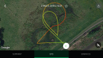
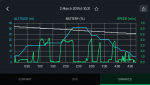
So - first (of many) dumb questions ... in the flight history in Free Flight 6, on the GPS view, it shows the flight path on a map with colour-coded lines - green, yellow and red. Can anyone tell me what the colours signify? By comparing several flights remembering what modes I was using, I had some theories what the colours could mean but nothing stacks up, i.e. battery usage, altitude, flight mode.... can't figure it out. Does anyone know, please ?

A good simple example attached.....

Thanks
Joe
1383
 
hi,
yep that indicate altitude you get the same informations if you do a flight plan.
 
Thanks both of you for the information... now I know what I'm looking for it does make sense. Haven't done a flight plan yet but that's next on my list of things to learn :)
 
Had a chance to go out out and do a couple of flights today at the local park, so I thought I would try and figure out if the colours relate to specific low - high altitudes. The results have only got me more confused ....

I'd assumed that if green meant 'low' altitude then red would mean 'high' or possibly vice-versa. However, on the first test I flew it up and down the park at 5, 10, 20, 30 and then 50m altitude. The colours show first path as green, then yellow, then red for the highest ones.

Second test flight was just up and down at 1m - so you'd assume this would be green. Instead, it's entirely red. So, I have no idea!!

(as a separate issue, you can see the 2nd flight entirely at 1m shows correctly as 1m in the screenshot. However on the 1st flight, all the altitudes are exactly 10m wrong.... the 5m path shows as 15m altitude, and all the steps up to 50m (showing 60m) are +10m. Whilst flying, the correct altitudes were definitely shown, but the log is wrong. I have seen this on previous flights but not kept enough of a record to be totally sure of the differences. This time I had noted it. And of course it's not consistent as the 2nd flight at 1m is correct)1390139113921393
 
The colour may be relative to the maximum height of the flight. Try flying at 1, 2 and 3m and see what happens.
 
Last edited:
Thanks for your suggestion... will give that a go, though probably need to wait until the weekend ...
 
My guess is the color is calculated at the end of Flight as a percentage of the highest altitude of the whole flight.
For example :
  • In a flight from 0 m to 50 m, 0 m will be green, 10 m will be yellow, 20 m will be orange-yellowing, 30 m will be orange, 40 m will be dark orange and finally 50 m will be red.
  • In a flight from 0 m to 1 m, climbing directly from 0 m to 1 m like shown in your flight log, 0m will be green, but you won’t see it because you go directly to the ‘highest altitude of 1 m’, then the rest of the flight will be red (highest), then it should resume to green during landing but can’t be seen because you landed at the same point ‘almost’ vertically, so you can’t see a green branch.
A good test would be to go from take off to 5 m with a slight regular slope up to the middle of the flight journey, then land from 5 m to 0 with a slight slope too.
It should result in a beautiful medley of colors from green to red then back to green ;o)
 
Last edited:
I think the colors are related to the speed of the drone. Green for a small speed up to a high speed.
 
Using the log file in google earth it clearly shows the different colors as altitude. This was going up to take a 360 pano and back down again.

1404
 
I did what I proposed on the post above :

  • Take off
  • Stabilize at 1 m and fligh a meter straight (green)
  • Turn right and make a straight line of 10 m at constant speed from 1 m high to 3 meters high (from green to red)
  • Turn right again at the same altitude of 3 m in a straight line of 1 m (red as max alt.)
  • Turn right
  • Come back at a constant speed in a 10 m Line and a regular descent back to 1 m (from red to green)
  • Land
1418

Conclusion 1 : the color is proportional to the relative heigth of the drone (a % of the highest point reached) and is not related to speed.
Conclusion 2 : Nice Colors aren’t they ?
 
Last edited:
  • Like
Reactions: Dirk_ANAFI
I did what I proposed on the post above :

Conclusion 1 : the color is proportional to the relative heigth of the drone (a % of the highest point reached) and is not related to speed.
Conclusion 2 : Nice Colors aren’t they ?

Many thanks for your research. I did something similar today and came to the same conclusion - colour does seem proportional rather than relating to fixed specified altitudes.

I think it's quite easy to get confused about why it's not showing red tracks for the highest altitudes, but in a couple of my tests when I was at the highest point, I had only moved vertically (up and down) so having covered no horizontal distance at that altitude there's no track. Initially I couldn't think why no part was red!
 

Attachments

  • 2019-03-02 11.54.18.png
    2019-03-02 11.54.18.png
    2.4 MB · Views: 11
  • 2019-03-02 11.54.24.png
    2019-03-02 11.54.24.png
    129.7 KB · Views: 12
  • Like
Reactions: MustangPhil
I wonder how the colouring works if you fly above AND below the take-off altitude ?
 

New Posts

Members online

No members online now.

Forum statistics

Threads
5,307
Messages
45,098
Members
8,000
Latest member
Critinator