Welcome to our Community
Wanting to join the rest of our members? Feel free to sign up today.
Sign up

Free flight 6 update 6.4.3 on iOS and Android

It says that the update only improves the stability of the app, not a big update at all

Make sure you re-calibrate after the update. My drone was flying fine but after the update i had two minor crashes due to "toilet bowling". But to be fair i tried to re-calibrate next to the crash site and it said to move away from metallic objects and i was here: Google Maps so maybe something to do with the refinery. I was lucky though the first crash was heading out into the canal but i stopped it with my hand. Afterwards i headed out about 1/2 mile up the path, re-calibrated and everything was fine
 
Make sure you re-calibrate after the update. My drone was flying fine but after the update i had two minor crashes due to "toilet bowling". But to be fair i tried to re-calibrate next to the crash site and it said to move away from metallic objects and i was here: Google Maps so maybe something to do with the refinery. I was lucky though the first crash was heading out into the canal but i stopped it with my hand. Afterwards i headed out about 1/2 mile up the path, re-calibrated and everything was fine

Could you please do the following :
- Go to the exact same spot with a hand magnetic compass.
- Make some measurements of the ‘north position’ at the spot level, at ground level and at eye level heigth.
- Move 1 m or 5 meters around the take off point to check consistency of the north indication of the compass.

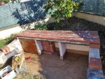
I am now certain that my drifting issues near my BBQ are due to magnetic perturbations of 3 metallic bars I embedded in the structure when I built the BBQ.
I just stuck paper ‘arrows’ on it to indicate the north and here were my findings :
1791

1 meter above the BBQ, I do not have this ‘magnetic mess’

Thanks for you report !
 
  • Wow
Reactions: Krusty Geeza
With this new upgrade, I did not notice the ‘Precise RTH’ message with my Android phone. Did you get it ?
 
With this new upgrade, I did not notice the ‘Precise RTH’ message with my Android phone. Did you get it ?

Seems to be an intermittent issue. Went out and flew 3 test flights today since the update and I got the 'Precise RTH' message only on flight 2. (Android).

However I think this issue was introduced in 6.4.1 as this happened intermittently to me before today's update (but not before 6.4.1)
 
  • Like
Reactions: MustangPhil
I would say it is intermittent also. I have had it a few times where I did not get the message showing. It seems to work more often when I use the "take off" icon on the phone rather then the RC.
 
  • Like
Reactions: MustangPhil
Could you please do the following :
- Go to the exact same spot with a hand magnetic compass.
- Make some measurements of the ‘north position’ at the spot level, at ground level and at eye level heigth.
- Move 1 m or 5 meters around the take off point to check consistency of the north indication of the compass.

I am now certain that my drifting issues near my BBQ are due to magnetic perturbations of 3 metallic bars I embedded in the structure when I built the BBQ.
I just stuck paper ‘arrows’ on it to indicate the north and here were my findings :
View attachment 1791

1 meter above the BBQ, I do not have this ‘magnetic mess’

Thanks for you report !

No problem :) Unfortunately i dont have a magnetic compass or paper arrows :(
 
  • Wow
Reactions: Jed Anafi
A magnetic compass is really useful for this purpose (and hiking) and you can find cheap ones at Decathlon or Amazon.uk (less that 10£)
The paper arrows are not necessary, I made them with a inkjet printer and simple A4 paper, but in your case, do not make them. Just walk around and check consistency of the indicated ‘north’.
If not consistant, just take note of the min/max difference (in my case on the BBQ with pictures above I found a 360° difference, but on the car roof, I found +/-40° difference (for a total of 80° ... and that’s a lot !)
 
In fact, I remarked the compass App from my smartphone (using a mems magnetometer sensor) is really precise, but is less prone to magnetic perturbations than an actual compass. That’s why I use a compass.
 
In fact, I remarked the compass App from my smartphone (using a mems magnetometer sensor) is really precise, but is less prone to magnetic perturbations than an actual compass. That’s why I use a compass.
Ok. I thought, that the magnetic aberration can also be watched on a compass app.
 
Doing more testing today on PL and I found if I only had 12-13 satellites I would not get the message for PL. When I got 14 plus satellites the message appeared on take off. So I am guessing it needs good satellite coverage to work right.
 
I’ll check the satellites number on the json file, but I did the satellite number checking before to take off (not only the green icon, but clicked on the Drone icon to check the numbers, and I am pretty sure they were above 15).

Magnetometer sensors are also sensitive to magnetic perturbations (and there is of course one in the Anafi). The ‘calibration danse’ of the Anafi is made on purpose to check the 3 directions of the measured magnetic field (rotations around x,y and z axis that this type of sensor analyses), but it also implies other sensors (accelerometer for example) and filtering algorithms that give results very different to a hand compass. The hand compass will just have a center of the needle that is slightly offset to maintain the needle ‘flat’ when the actual north should point 40% to the north and 60% point to the earth center ( under our feet) at our latitudes (around the North Pole, the magnetic field of the ‘north’ is directed 100% under our feet).
So a compass app on a phone or the magnetometer and Parrot’s associated algorithms will try to apply ‘corrections’ to the indications of the ‘north’ whereas the needle of the compass will just point what it finds to be the north (sorry for my poor English and the long text !)
 
Last edited:
I’ll check the satellites number on the json file, but I did the satellite number checking before to take off (not only the green icon, but clicked on the Drone icon to check the numbers, and I am pretty sure they were above 15).

Magnetometer sensors are also sensitive to magnetic perturbations (and there is of course one in the Anafi). The ‘calibration danse’ of the Anafi is made on purpose to check the 3 directions of the measured magnetic field (rotations around x,y and z axis that this type of sensor analyses), but it also implies other sensors (accelerometer for example) and filtering algorithms that give results very different to a hand compass. The hand compass will just have a center of the needle that is slightly offset to maintain the needle ‘flat’ when the actual north should point 40% to the north and 60% point to the earth center ( under our feet) at our latitudes (around the North Pole, the magnetic field of the ‘north’ is directed 100% under our feet).
So a compass app on a phone or the magnetometer and Parrot’s associated algorithms will try to apply ‘corrections’ to the indications of the ‘north’ whereas the needle of the compass will just point what it finds to be the north (sorry for my poor English and the long text !)
MEMS based electronic compasses of course have a tilt compensation, but that's the same what you do when balancing a compass horizontally in your hand. So I think both would show a north aberration if it exists.
 
A magnetic compass is really useful for this purpose (and hiking) and you can find cheap ones at Decathlon or Amazon.uk (less that 10£)
The paper arrows are not necessary, I made them with a inkjet printer and simple A4 paper, but in your case, do not make them. Just walk around and check consistency of the indicated ‘north’.
If not consistant, just take note of the min/max difference (in my case on the BBQ with pictures above I found a 360° difference, but on the car roof, I found +/-40° difference (for a total of 80° ... and that’s a lot !)

I do think i'll have get one even if it is just for hiking. I think you are completely correct though! I was commenting on a different topic about this spot and remembered i had my first crash here back in September 2018.

Skip forward to 2:22


and now compare this with a couple of days ago:

 
I do remind that a few years ago when i was traveling a lot to Amsterdam, there was a piece of the road where my GPS wnetalways wrong, despite the road was straight. I can imagine large metalic objects (or fancy buildings) might interfere with the GPS signal (radiosignal reflections), besides that magnetism might be an indication of direction for the drone's code.
Well at the end of this month SDK comes public i red, so then maybe it be possible to better investigate what is so special about those areas, and be able to tell if some sensors could be used to resolve it in another way... just thinking as a developer (not working for parrot). ( I'm realy curious about what the ground camera can see, can it be used for direction as well perhaps ?. )
 
The last update doesn't fix that bug:
If you want to download single media from the gallery by simply tapping on the media icon, everything works fine for the first time. If you then try to download further single media, the download doesn't start and you were asked instead, whether you want to delete the media on the SD card.
A workaround is to leave the gallery after downloading the first picture. Going back to the gallery, you can again download ONE file.
 

Members online

No members online now.

Forum statistics

Threads
5,319
Messages
45,175
Members
8,035
Latest member
goodman1111