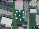
That is an interesting article Rocky. It explains the accuracy of Lat and Long figures but does not mention the accuracy, or should it be inaccuracy, of the Lat/Long data from the GPS module. Your test in your corral will show the repeatability of the figures but unless you know the exact position of the corners it will not show the error of GPS against actual Lat/Long.
If you knew the accurate Lat and Long of a spot could you place the Anafi on the ground with the its GPS directly above the known spot and take a photo? If you then examine the exif data of the photo you should find out how far off the GPS is. Doing that on different days with different satellites in view would build up a picture of the error. You would have to let the Anafi sit for a while before taking the photo to let it see as many satellites as possible and reduce the error.
My reply:
"And that opens up a whole 'nuther can o' worms! I have USGS topos on disk but since my house was built long after that survey I can't correlate any post. Then there's the NAD27 to NAD 83 or WGS84 question. I can get pretty accurate subdivision plats from the county and find the corners of the lot but then how do I know the surveyors were accurate? I
CAN find some nearby benchmarks and look them up in the USGS database; that is probably the most accurate points I can use. Then I have to do the conversion to WGS84 which I'm pretty sure the Anafi uses. Then I have to actually
locate the benchmark, put the drone on it, fly it up 20 feet and back down, then look at the json and correlate that to the benchmark.......
This is beginning to look like a wormhole not a can of worms!

I think I'll live with 1-2 meter accuracy since my end result will always be a photograph...if it shows what I expect all is good.

"


