Welcome to our Community
Wanting to join the rest of our members? Feel free to sign up today.
Sign up

360 Photo in FP

IronSky1

Well-known member
Joined
Jan 16, 2019
Messages
363
Reaction score
102
Location
Algonquin Il USA
Has anyone been able to get 360 pano mode to work in Flight Plan? I was trying to create a FP that can be repeated over and over in as the seasons change in autonomous mode from the same position (which is easier to get to by autonomous flight then going there.
 
Last edited:
  • Like
Reactions: Bruchpilot
My approach to a task like this:

Create a flightplan, TO the location you wanna do the 360!
End it there.
Do your 360, RTH or another flight plan to another 360 position, 360, ....


And repeat that the next time!
 
Understood done that just cannot get into 360 sphere mode (photo). I goes into 360 however, it does not do the auto rotation two axis taking all the shots for a 360 sphere. Maybe I was not explaining correctly. Problem is that it will loose wifi because of elevation changes and distance so how do I start a 360 sphere when I loose contact I would need in plan which I have not been able to do.

Thanks
 
Thanks not that big a deal worst case I can walk over there only .75 mile was just try to retain position as close as possible and keep out of snow with foot prints. The link allows Parrot owners to create custome plans and load into a Android device? Very nice worth supporting especially if it can be transported between devices as one upgrades.
 
Did a simple test this morning using the above program. It started taking photos then stopped for some reason. I found it hard to get the timing for photos to be taken and the rotation of the Anafi to sync. The Litchi program I believe will allow you to program a 360 panel but for our use with litchi we are very limited to what commands the Anafi understands. It does not except the photo and video commands from Litchi.
 
Even Litchi is ONLY giving camera angle changes in case the bird is connected to the remote and app.
That is, why all this "distance" missions are coming with one angle setting for the cam.
So I highly doubt, that would be any different.
That is, why I fly 360 "missions" TO a point and make sure, I have free LOS in the range of the remote.
And stat the 360 then myself.
I think that 3/4 of a mile should work, with the Anafi.
Even 1.5 miles will do, as long there is nothing in the path between remote and bird
Sometimes it pays out to start further away, if that gets you a free view to the location you wanna use the bird
I am not 100% certain, but I can't recall that litchi is even offering a 360 function in missions.
Picture, yes, timelapse, yes, video, yes, switching between, yes.
But all needs the app connected to the bird.
And 360? Never seen that, maybe they added it.
Just then is the question: Could FF6 read that info?
Looking at the "smoothness" of in mission camera usage, I have my doubts!
 
Well Litchi has a Panorama Preset. Not sure if you can make it do a full 360 but it looks like you can combine a bunch to get the 360 to work but since it does not work very well with the Anafi it would just be a waist of time to explore it farther.
 
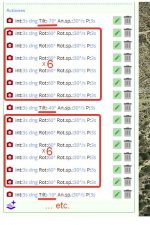
I can offer the following solution. Add overlapping photos to your flight plan and then create a panorama from them on your computer.

2020-11-23_09-50-37.jpg
The rotation angles are shown for example. You may need a larger overlay.
 
  • Like
Reactions: Jagerbomb52
Well the last two days I have been experimenting trying to create a 360 pano using @abant program. My last attempt was close but for some reason will not complete a full 360 degree turn to take the photos needed. One problem I was having with some of my attempts it wanted to do a time lapse of photos. Not sure why. I basically have given up. My thought is if @abant can convert his orbit so it will do a 360 that might be our best option but I am no expert at his program so I will let him decide if it is worth pursuing. I'm sure it is very time consuming coding the right info into his program.
 
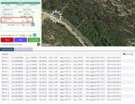
This is a good idea. You can use the orbit by setting the position of the drone perpendicular to the direction of flight. You can overlay several orbits one after the other, changing the camera angle for each of them.

2020-11-24_17-22-37.jpg
 
@abant
Is there anyway to have the Anafi stay in one spot? Not sure on how well pictures would get stitched together at the minimum 5 meter orbit.
Yes, there is such a way. You can add multiple paused rotation actions to a single point.
 
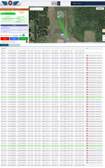
This morning I managed to use the orbit to make a 5 layer orbit. Each one had a different camera angle. What I thought should have been around a 40 photo capture ended up being 105 photos. I suspect it had to do with the timing I had set for each photo. I was only at 10 feet above the ground and the final 360 was a bit concaved but that could have been from the number of photos and the closeness to the ground. All in all it turned out pretty well.
I used PanoramaStudio 3 Pro to stitch the photos. There was one spot were you could see the seam but I have had that happen even with a true Anafi 360. So with a little work you can reproduce a 360 photo using @abant program. I have not yet tried adding it to a waypoint mission but I see no reason it would be to difficult to do, just insert it into your mission and it should be good to go. I also tried inputting a lower number then 5 feet radius. Not sure if it worked but it seems it did somewhat.

V4Mvr7M.jpg


screenshot-esparus.online-2020.11.25-10_55_42.png
 

Attachments

  • abant 360 5 layers.jpg
    8.3 MB · Views: 4
  • Like
Reactions: abant
I changed the minimum allowed radius, now you can set it to 1. I think that with such a radius, it doesn't matter how you will orient the drone to take a panorama - in the direction of the center of the orbit or in the opposite direction.

P.S. I haven't been to Canada. But the landscape in the photo looks like it was taken in Finland or Russia. I don't think there is a single person who can say for sure that this is Canada. Except, of course, those who are familiar with this place.
 
  • Like
Reactions: Jagerbomb52
Well abant this is just a very small part of my back yard in the small country village I live in. There are much nicer places around the village then my back yard LOL
Oh and thanks for making the adjustment.
 
Did a final test today of making up a fight plan from point A to point B and then have it do a 360 panel using the Orbit function. I would say it was a success. I did run into one problem when the Anafi was taking photos straight up at the sky the camera got locked up. (Zenith) Perhaps the speed I was asking it to take photos was just to fast for it. I got the message to check to see if anything was blocking the camera so I had to land and restart the Anafi which corrected the problem but i would have had rerun the flight plan to get all the photos. Even so it still produced a pretty good pano using PanoramaStudio 3 Pro with the photos already taken.
You will need to run a few tests and make adjustments that work for you. Once you get the hang of layering the different Orbits and the camera angles it all falls into place. Perhaps not the best solution but it does work for a flightplan mission and taking a 360 pano at any spot along the way.

One other thing. I used 8 photos for each layer. I would try and get maybe 10 or 12 for each layer. Having more is always a good thing. If you don't need them you can always delete them later.

My over all flight plan:

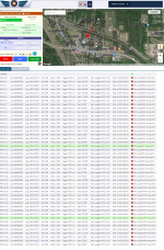
screenshot-esparus.online-2020.11.26-07_57_12.png

The Pano that was produced from the photos using PanoramaStudio 3 Pro:


T5BYrVL.jpg
 
@abant
Some things I have noticed.
If I make a mission at a different location and try to insert my saved 360 Orbit it will not load on the waypoint I want it to do the 360 pano. I have to move the POI close to the spot and even then it is off by X amount of feet. Perhaps I am not doing something right but it seems to be geared to where the POI is on the map.
Also it would be nice to drag and drop the POI just like we can with waypoints.
Hopefully you can tell me if I am doing something wrong and perhaps a easier way of doing this.
Thanks
 
I'm not sure I fully understood the problem. However, if you are referring to the exact positioning of each part of the flight plan on the map, keep in mind that when inserting saved plans, the POI is the reference point. This should be kept in mind when you save a flight plan that you intend to use later as part of another plan. To solve your problem, I would recommend a sequence of actions, as in this video. Note that when creating an orbit, I use the orientation to the center, but not to the POI.
 
  • Like
Reactions: Jagerbomb52

New Posts

Members online

No members online now.

Forum statistics

Threads
5,295
Messages
45,053
Members
7,965
Latest member
Peanut