Welcome to our Community
Wanting to join the rest of our members? Feel free to sign up today.
Sign up

Lost/Found Anafi

rania

New member
Joined
Feb 2, 2021
Messages
2
Reaction score
0
Hello fellow pilots,

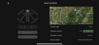
I sadly lost my drone today. Here are the following coordinates in the picture. It got pushed in a gust of wind and I lost control while trying to make it land. I went to the coordinates and said I was right on top of the pin however I couldn't find it. There's also about a couple feet of snow there at the moment. There are marked trees with trails so it's doable just too dangerous in the snow covered trails. I swore I could have seen it but was too hard to tell. I plan on going back as it's a very well known place called High Rock so I plan to go back in the Spring just to try again when snow is gone but if anyone has any tips/tricks or is ever in that area and finds it, it's registered and has a sticker on it with the #. IMG-0330.PNG
 
Sorry to hear that, maybe some binoculars would help
Usually last known position is pretty accurate within 30 feet or so.
But if drone signal was lost to phone during landing and wind pushed it away it may not reflect accurate position
Always a good idea to have a phone screen recording running for situations like this
Wish you the best of luck on recovery
 
  • Like
Reactions: rania
Strange. I put those coords in google earth and it shows thick vegetation, possibly in a tree.
It shows the Anafi was west of the town Flinton PA.

I had this happen before and never recovered the Anafi. Good luck.
must have been very strong winds or tornado to travel that far ;)
 
must have been very strong winds or tornado to travel that far ;)
it said it was only 450 feet away, about a 3 minute walk, and it was an overlook so it can get windy...I was able to walk to the pin looked up couldn't find it in a tree couldn't find any marks from the untouched snow, it could have been give or take another 30ft in another direction like @BRC stated.
 
Hello fellow pilots,

I sadly lost my drone today. Here are the following coordinates in the picture. It got pushed in a gust of wind and I lost control while trying to make it land. I went to the coordinates and said I was right on top of the pin however I couldn't find it. There's also about a couple feet of snow there at the moment. There are marked trees with trails so it's doable just too dangerous in the snow covered trails. I swore I could have seen it but was too hard to tell. I plan on going back as it's a very well known place called High Rock so I plan to go back in the Spring just to try again when snow is gone but if anyone has any tips/tricks or is ever in that area and finds it, it's registered and has a sticker on it with the #. View attachment 5376
I lost my anafi on the 10 june I found it on the 23 june the map will a long why from the position on your map what I did is contacted Parrot support and asked for there flight record because these drones send real time data by satellites my had sent over 15 positioning gps after landing they were all different but in a general area of about 20 meters radius your problem will be your starting position gps in relation to what they can supply which they could be not to keen of giving them to you my drone had given gps beeps as long as it had power remember if you use any gps as your starting point it can say within 5 meter but it will be closer to 15m finding will only be luck if it takes less then a few hours best take so stakes and look in that area keep a record and you will find it.
 
No dude, that's not how it works.
yes it does because 8 weeks ago they gave me the real time data and I had only had the drone for 3 days before I lost it and the amount of data is large and my drone had not been in the air for more than 30 mins,I litterally bought the Parrot Anafi because data is collected in real time and I thought that at so point I will need the data because I will not know were it has landed.You might think that data is sent by internet but its by satellite.Every Drone that has Satellite connection is sending real time data because if anything that has GPS has to send real time data and if not there is no known point that is a surveying term in plain English it means any positioning points have no value.I spent 3 years from 9 am to 5 pm Monday to Friday being taught Surveying this is before computers and calculators were viewed that the person with one should not be there.GPS positioning is so inaccurate that it can never be True.That is a surveying term the starting point must be true if not nothing from that point has any value. I have just explained why alot of crashes happen its because they believe their position points (GPS, distance ,altitude the reading on the screen are literally not true
 
yes it does because 8 weeks ago they gave me the real time data and I had only had the drone for 3 days before I lost it and the amount of data is large and my drone had not been in the air for more than 30 mins,I litterally bought the Parrot Anafi because data is collected in real time and I thought that at so point I will need the data because I will not know were it has landed.You might think that data is sent by internet but its by satellite.Every Drone that has Satellite connection is sending real time data because if anything that has GPS has to send real time data and if not there is no known point that is a surveying term in plain English it means any positioning points have no value.I spent 3 years from 9 am to 5 pm Monday to Friday being taught Surveying this is before computers and calculators were viewed that the person with one should not be there.GPS positioning is so inaccurate that it can never be True.That is a surveying term the starting point must be true if not nothing from that point has any value. I have just explained why alot of crashes happen its because they believe their position points (GPS, distance ,altitude the reading on the screen are literally not true

I don't like to ever questions someone's intelligence or anything, but nothing you wrote is remotely true or correct.

With the internet it is very easy to get an in depth knowledge on things or at a minimum some basic understanding on how something works before posting utter nonsense...
 
I don't like to ever questions someone's intelligence or anything, but nothing you wrote is remotely true or correct.

With the internet it is very easy to get an in depth knowledge on things or at a minimum some basic understanding on how something works before posting utter nonsense...
Why would you describe yourself that way because you are describing yourself perfectly .I am a qualified in land surveying that is a person who understands what points of reference are here something else I am qualified in electronics as in how things work. Parrot the company gave me everything all the real time data. As for the term fly away if there is no last GPS when its landed or crashed that would make everything to do with positioning points fake. As you believe the internet is a place were depth of knowledge can be found you will have found after reading this.
 
Why would you describe yourself that way because you are describing yourself perfectly .I am a qualified in land surveying that is a person who understands what points of reference are here something else I am qualified in electronics as in how things work. Parrot the company gave me everything all the real time data. As for the term fly away if there is no last GPS when its landed or crashed that would make everything to do with positioning points fake. As you believe the internet is a place were depth of knowledge can be found you will have found after reading this.
Most of us have been Parrot Anafi owners since the day Parrot brought them out. We have all travelled a journey with Parrot, and the one thing we have learned is that Parrot does NOT have a boat load of data on each flight we make.

The minute anyone losses their Anafi and contact Parrot, we get the same thing all the time: "We need the flight data from the Anafi". I personally have been communicating one of the development directors for sometime, and its been suggested on numerous occasions for them to look at a way of allowing the Anafi to collect and harvest data during a flight and either download to them or download to the phone we are using, and always they come back and tell us that's not possible.

The Anafi doesn't complete the flight data until its landed and completed. Which is why many have struggled to get data when their craft has ended up in the water without the flight finishing.

We have been going through this for years, and there are guys on here who know every little bit of the Anafi.

It may do "Live data" with the Anafi USA, but certainly doesn't do it it with the standard Anafi.
 
Why would you describe yourself that way because you are describing yourself perfectly .I am a qualified in land surveying that is a person who understands what points of reference are here something else I am qualified in electronics as in how things work. Parrot the company gave me everything all the real time data. As for the term fly away if there is no last GPS when its landed or crashed that would make everything to do with positioning points fake. As you believe the internet is a place were depth of knowledge can be found you will have found after reading this.

I really do not know how to respond to this.

You are either having a joke with us -or- you are doing your best to troll.

Anyway, enjoy your real-time data uploaded by your $500 consumer drone to some unspecified satellite network, where the data transfers seem to be free. which Parrot uses to help locate your lost drone, all while not making any mention of this in their user manuals / operating guides / white papers on drone technology and not having any physical hardware on the drone that could possible do this..... Just amazing.
 
  • Like
Reactions: d95gas
I really do not know how to respond to this.

You are either having a joke with us -or- you are doing your best to troll.

Anyway, enjoy your real-time data uploaded by your $500 consumer drone to some unspecified satellite network, where the data transfers seem to be free. which Parrot uses to help locate your lost drone, all while not making any mention of this in their user manuals / operating guides / white papers on drone technology and not having any physical hardware on the drone that could possible do this..... Just amazing.
When a person buys technical equipment most have no understanding of how it works, anything that has GPS must be in real time for if its not in real time there is no GPS and that would make any company saying that it has GPS positioning liars, miss selling, and when a company is a proven liar that company is finished. As Parrot app gives distance speed based on GPS it is in real time. But when a person dose not understand the technology when they contact the company they say the wrong things and when a person asks the question wrongly that person will not understand the answer
 
The GNSS chip (GNSS includes GPS, GLONASS and/or other positioning systems) has a real time clock to measure signal delay and phase that are sent by different satellites. GNSS chip has only a receiver, nothing will be sent to sats. Coordinates/altitude will be computed and validated inside the GNSS chip ( i.e. UBLOX MAX-M8 series). Positioning data will be sent via serial connection to flight controller. This is no more real time and cannot be. Flight controller records positioning data 1 time per second (1Hz) for logging. This is good enough for exact postioning.

Logging data can be uploaded later to a Parrot server via internet connection if abailable but I prefere local storage.

@Anthony: I do not know what you mean with real time but you conclusions are not understandable in this context. Could it be you mixed up some things?

br HE
 
Hello fellow pilots,

I sadly lost my drone today. Here are the following coordinates in the picture. It got pushed in a gust of wind and I lost control while trying to make it land. I went to the coordinates and said I was right on top of the pin however I couldn't find it. There's also about a couple feet of snow there at the moment. There are marked trees with trails so it's doable just too dangerous in the snow covered trails. I swore I could have seen it but was too hard to tell. I plan on going back as it's a very well known place called High Rock so I plan to go back in the Spring just to try again when snow is gone but if anyone has any tips/tricks or is ever in that area and finds it, it's registered and has a sticker on it with the #. View attachment 5376
I have always a Wifi analyser on my phone. I've lost my drones on a few occasions where they landed in high grass. It works only if the drone didn't shut off. Go to the spot where you asume the drone landed and watch the signal strength. Start walking around and where the signal peaks you will find the drone to be only a few steps away. Wifi Analyzer - Apps op Google Play
 
  • Like
Reactions: h-elsner

Members online

No members online now.

Forum statistics

Threads
5,309
Messages
45,104
Members
8,007
Latest member
folgorem