Vaakefjell
Well-known member
- Joined
- Dec 13, 2021
- Messages
- 57
- Reaction score
- 25
@t3l3tubie this is standard exif info from a random photo from my Anafi 4K, pulled with exiftool:
ExifTool Version Number : 12.41
File Name : P6265913.JPG
File Size : 5.2 MiB
File Modification Date/Time : 2022:04:13 15:52:06+02:00
File Access Date/Time : 2022:06:08 21:54:22+02:00
File Creation Date/Time : 2022:04:13 21:43:50+02:00
File Permissions : -rw-rw-rw-
File Type : JPEG
File Type Extension : jpg
MIME Type : image/jpeg
JFIF Version : 1.01
Exif Byte Order : Little-endian (Intel, II)
X Resolution : 72
Y Resolution : 72
Resolution Unit : inches
Image Description : Anafi 1.8.2
Make : Parrot
Camera Model Name : Anafi
Orientation : Horizontal (normal)
Software : anafi-4k-1.8.2
Modify Date : 2022:04:13 17:52:06
Y Cb Cr Positioning : Centered
Exposure Time : 1/81
F Number : 2.4
Exposure Program : Program AE
ISO : 400
Sensitivity Type : ISO Speed
ISO Speed : 400
Exif Version : 0231
Offset Time : +02:00
Date/Time Original : 2022:04:13 17:52:06
Offset Time Original : +02:00
Create Date : 2022:04:13 17:52:06
Offset Time Digitized : +02:00
Components Configuration : Y, Cb, Cr, -
Shutter Speed Value : 1/81
Aperture Value : 2.4
Exposure Compensation : 0
Metering Mode : Center-weighted average
Flash : No Flash
Focal Length : 4.0 mm
Sub Sec Time : 283
Sub Sec Time Original : 283
Sub Sec Time Digitized : 283
Flashpix Version : 0100
Color Space : sRGB
Exif Image Width : 5344
Exif Image Height : 4016
Focal Plane X Resolution : 7391.120057
Focal Plane Y Resolution : 7391.120057
Focal Plane Resolution Unit : cm
File Source : Digital Camera
Scene Type : Directly photographed
Exposure Mode : Auto
White Balance : Auto
Light Source : Unknown
Focal Length In 35mm Format : 20 mm
Scene Capture Type : Standard
Contrast : Low
Saturation : Low
Sharpness : Soft
GPS Version ID : 2.3.0.0
GPS Altitude Ref : Above Sea Level
GPS Satellites : 23
Compression : JPEG (old-style)
Thumbnail Offset : 1115
Thumbnail Length : 23215
XMP Toolkit : GStreamer
Flight uid : 2022:04:13 17:44:08+02:00
Vehicle uuid : PI040416BA8H089921
Drone Roll Degree : -6.558635
Drone Pitch Degree : 17.549625
Drone Yaw Degree : 175.858246
Camera Roll Degree : -0.322913
Camera Pitch Degree : -78.362686
Camera Yaw Degree : 176.310745
Model Id : 0914
Visible Camera Roll Degree : -0.322913
Visible Camera Pitch Degree : -78.362686
Visible Camera Yaw Degree : 176.310745
Serial Number : PI040416BA8H089921
Software Version : 1.8.2
Software Build Id : anafi-4k-1.8.2
Capture Ts Us : 575425666
Boot Id : 0BE22A352A4A9C89F894AE420B4A226B
Run Id : 14B4D0E218C2B5BEC687CC0B34DB930A
Run Date : 2022:04:13 17:44:08+02:00
Photo Mode : Single
Pitch : 11.637153
Yaw : 175.981049
Above Ground Altitude : 223.073257446289
GPSXY Accuracy : 0.880056789527313
GPSZ Accuracy : 1.39999997615814
Roll : -0.066503
Date : 2022:04:13 17:52:06.283000+02:00
Format : image/jpeg
Description : Anafi 1.8.2
Comment : Anafi 1.8.2
Image Width : 5344
Image Height : 4016
Encoding Process : Baseline DCT, Huffman coding
Bits Per Sample : 8
Color Components : 3
Y Cb Cr Sub Sampling : YCbCr4:2:2 (2 1)
Aperture : 2.4
Image Size : 5344x4016
Megapixels : 21.5
Scale Factor To 35 mm Equivalent: 5.0
Shutter Speed : 1/81
Create Date : 2022:04:13 17:52:06.283+02:00
Date/Time Original : 2022:04:13 17:52:06.283+02:00
Modify Date : 2022:04:13 17:52:06.283+02:00
Thumbnail Image : (Binary data 23215 bytes, use -b option to extract)
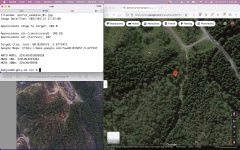
GPS Altitude : 305.3 m Above Sea Level
GPS Latitude : 60 deg 2' 2.50" N
GPS Longitude : 5 deg 40' 38.28" E
GPS Latitude Ref : North
GPS Longitude Ref : East
Circle Of Confusion : 0.006 mm
Field Of View : 84.0 deg
Focal Length : 4.0 mm (35 mm equivalent: 20.0 mm)
GPS Position : 60 deg 2' 2.50" N, 5 deg 40' 38.28" E
Hyperfocal Distance : 1.11 m
Light Value : 6.9
View attachment P6265913.JPG
ExifTool Version Number : 12.41
File Name : P6265913.JPG
File Size : 5.2 MiB
File Modification Date/Time : 2022:04:13 15:52:06+02:00
File Access Date/Time : 2022:06:08 21:54:22+02:00
File Creation Date/Time : 2022:04:13 21:43:50+02:00
File Permissions : -rw-rw-rw-
File Type : JPEG
File Type Extension : jpg
MIME Type : image/jpeg
JFIF Version : 1.01
Exif Byte Order : Little-endian (Intel, II)
X Resolution : 72
Y Resolution : 72
Resolution Unit : inches
Image Description : Anafi 1.8.2
Make : Parrot
Camera Model Name : Anafi
Orientation : Horizontal (normal)
Software : anafi-4k-1.8.2
Modify Date : 2022:04:13 17:52:06
Y Cb Cr Positioning : Centered
Exposure Time : 1/81
F Number : 2.4
Exposure Program : Program AE
ISO : 400
Sensitivity Type : ISO Speed
ISO Speed : 400
Exif Version : 0231
Offset Time : +02:00
Date/Time Original : 2022:04:13 17:52:06
Offset Time Original : +02:00
Create Date : 2022:04:13 17:52:06
Offset Time Digitized : +02:00
Components Configuration : Y, Cb, Cr, -
Shutter Speed Value : 1/81
Aperture Value : 2.4
Exposure Compensation : 0
Metering Mode : Center-weighted average
Flash : No Flash
Focal Length : 4.0 mm
Sub Sec Time : 283
Sub Sec Time Original : 283
Sub Sec Time Digitized : 283
Flashpix Version : 0100
Color Space : sRGB
Exif Image Width : 5344
Exif Image Height : 4016
Focal Plane X Resolution : 7391.120057
Focal Plane Y Resolution : 7391.120057
Focal Plane Resolution Unit : cm
File Source : Digital Camera
Scene Type : Directly photographed
Exposure Mode : Auto
White Balance : Auto
Light Source : Unknown
Focal Length In 35mm Format : 20 mm
Scene Capture Type : Standard
Contrast : Low
Saturation : Low
Sharpness : Soft
GPS Version ID : 2.3.0.0
GPS Altitude Ref : Above Sea Level
GPS Satellites : 23
Compression : JPEG (old-style)
Thumbnail Offset : 1115
Thumbnail Length : 23215
XMP Toolkit : GStreamer
Flight uid : 2022:04:13 17:44:08+02:00
Vehicle uuid : PI040416BA8H089921
Drone Roll Degree : -6.558635
Drone Pitch Degree : 17.549625
Drone Yaw Degree : 175.858246
Camera Roll Degree : -0.322913
Camera Pitch Degree : -78.362686
Camera Yaw Degree : 176.310745
Model Id : 0914
Visible Camera Roll Degree : -0.322913
Visible Camera Pitch Degree : -78.362686
Visible Camera Yaw Degree : 176.310745
Serial Number : PI040416BA8H089921
Software Version : 1.8.2
Software Build Id : anafi-4k-1.8.2
Capture Ts Us : 575425666
Boot Id : 0BE22A352A4A9C89F894AE420B4A226B
Run Id : 14B4D0E218C2B5BEC687CC0B34DB930A
Run Date : 2022:04:13 17:44:08+02:00
Photo Mode : Single
Pitch : 11.637153
Yaw : 175.981049
Above Ground Altitude : 223.073257446289
GPSXY Accuracy : 0.880056789527313
GPSZ Accuracy : 1.39999997615814
Roll : -0.066503
Date : 2022:04:13 17:52:06.283000+02:00
Format : image/jpeg
Description : Anafi 1.8.2
Comment : Anafi 1.8.2
Image Width : 5344
Image Height : 4016
Encoding Process : Baseline DCT, Huffman coding
Bits Per Sample : 8
Color Components : 3
Y Cb Cr Sub Sampling : YCbCr4:2:2 (2 1)
Aperture : 2.4
Image Size : 5344x4016
Megapixels : 21.5
Scale Factor To 35 mm Equivalent: 5.0
Shutter Speed : 1/81
Create Date : 2022:04:13 17:52:06.283+02:00
Date/Time Original : 2022:04:13 17:52:06.283+02:00
Modify Date : 2022:04:13 17:52:06.283+02:00
Thumbnail Image : (Binary data 23215 bytes, use -b option to extract)
GPS Altitude : 305.3 m Above Sea Level
GPS Latitude : 60 deg 2' 2.50" N
GPS Longitude : 5 deg 40' 38.28" E
GPS Latitude Ref : North
GPS Longitude Ref : East
Circle Of Confusion : 0.006 mm
Field Of View : 84.0 deg
Focal Length : 4.0 mm (35 mm equivalent: 20.0 mm)
GPS Position : 60 deg 2' 2.50" N, 5 deg 40' 38.28" E
Hyperfocal Distance : 1.11 m
Light Value : 6.9
View attachment P6265913.JPG