Welcome to our Community
Wanting to join the rest of our members? Feel free to sign up today.
Sign up

Anafi is now Pix4Dcapture compatible...

MustangPhil

Well-known member
Joined
Jul 27, 2018
Messages
571
Reaction score
420
Location
France
Hello all,

I‘ve just subscribed to the new free App ‘Pix4Dcapture’ for iOS on my iPadmini 4 now that it supports the Anafi.

As it is rather intuitive and there are loads of tutorials on the net (including French tutorials from Paladrone ! Thanks to Stephane !!), I could programm a mission, cache the map, save missions...
... but I didn’t really dare to fly it yet !

Is anyone of you :

- Already flying Pix4Dcapture with the Anafi ?
- Knows if the App controls the Anafi during the flight or if the App transfers the mission to the Anafi that flies autonomously with the mission on board ?
- Knows if anything ‘turns vinaiger ‘ if we can manually take control of the Anafi ?
- At the end of the mission, is it possible to get all pictures directly from the drone (in a folder of the SD card for example) and use them in another software to create STL files for example ? (If we do not want to buy the Pix4D wonderful but expensive software).

If it is to new for us, I’ll try a little mission in an ‘empty field’ next week-end ;o)
 
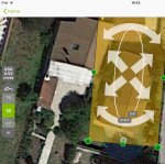
I also switched to the google satellite view (thanks to your trick) and I remarked my missions are a little ‘offset’ compared to the previous view. Looking at the screenshot you made, I am under the impression that the center of your programmed mission is also offset from the center of the bridge ?
 
Yes it seems to be. Thought I had manage to move myself but since you mentioned it I guess I did not. I wonder which one is more accurate.
 
Hello all,

I‘ve just subscribed to the new free App ‘Pix4Dcapture’ for iOS on my iPadmini 4 now that it supports the Anafi.

As it is rather intuitive and there are loads of tutorials on the net (including French tutorials from Paladrone ! Thanks to Stephane !!), I could programm a mission, cache the map, save missions...
... but I didn’t really dare to fly it yet !

Is anyone of you :

- Already flying Pix4Dcapture with the Anafi ?
- Knows if the App controls the Anafi during the flight or if the App transfers the mission to the Anafi that flies autonomously with the mission on board ?
- Knows if anything ‘turns vinaiger ‘ if we can manually take control of the Anafi ?
- At the end of the mission, is it possible to get all pictures directly from the drone (in a folder of the SD card for example) and use them in another software to create STL files for example ? (If we do not want to buy the Pix4D wonderful but expensive software).

If it is to new for us, I’ll try a little mission in an ‘empty field’ next week-end ;o)

already install yesterday but i not yet try it and the apps 15 days trial..so sad hear that
 
You don't need to use the Pix4D site to use the photos you collect with the App. There are other 3rd party options out there to upload your photos to or even software if you know where to look. All for free.
 
I was hoping to get out today and test this but the winds have picked up (35 mph @ 200 feet ) so I think I will just put it off for some other time.
 
I did the following test:

The setup : Switch on the Anafi and the Bluetooth GPS (Garmin Glo) that is connected to my iPad Mini 4 in Airplane mode but with Bluetooth on (as my iPad does not have a GPS, that’s how I fly and it is really precise).

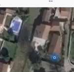
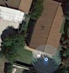
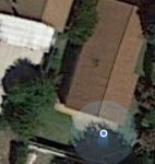
I looked at my real position (in my garden but on the ground, I didn’t have the guts to fly it) and took screenshots of how it is found on both my Garmin GPS and the Anafi GPS with FreeFlight 6 with in default map/satellite and did the same with Pix4Dcapture, both with the default satellite map and the Google default satellite map. I also checked my GPS position in Google Maps and found a kind of consistency...

My first impression is that both maps are offset in regard to my real position. But, even if the offset is not the same, the ‘error’ is about maximum 2 meters and that’s really great.
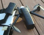
I also found the GPS from the Anafi is offset 0,50 to 1 meter from my Garmin Glo GPS (I did put them side by side like you can see on the picture so they should ‘sit’ one above the other).
The shaper image and more recent and ‘contrasty’ from the Google satellite view has convinced me to switch to the Google view. But I also feel that you can zoom to a more precise factor with the default view ... So the choice could depend on the width of the planned mission (I may be wrong).

I’ll post the screenshots below...
 
Last edited:
Not sure just how precise we really need it? Remember we are just taking over lapping photos. I suppose if you where doing survey work you would need something more accurate but then you would be looking at thousands of dollars for a good system.
 
The setting: Anafi + GPS Bluetooth external
F183DE97-682E-4A50-B7B7-91EB56633F5C.jpeg


Pix4Dcapture standard view:
B4D22CBA-12E9-4FE6-A56F-21275602A85F.jpeg

FreeFlight 6 screenshot:
913AF00F-7E39-401E-BCFE-D06EB9A4BFA7.jpeg

Google map sat view (rabbit=my real position)
DFCDAA9C-E67A-4CBB-87E9-BBF3A3C419EB.jpeg

Pix4Dcapture in Google sat mode:
3B6822E8-37F6-4DFE-8082-23406676258A.jpeg
 

Attachments

  • BBA460D8-9FD3-45C1-A0BB-4000DE285793.jpeg
    BBA460D8-9FD3-45C1-A0BB-4000DE285793.jpeg
    166.9 KB · Views: 15
Last edited:
Yes, I guess you are right, I will take a few meters more for the mission and that should be fine for my needs !
My concern with an error of 5 to 10 meters was the difference with a mission planned to be ‘around the building’ and ‘right inside the building’ ;o)
... I’ll try to keep it ‘above the building’ anyway and ‘Far from the high surrounding trees’
 
Last edited:
Just for your info, Stephane from Paladrone is a very experienced guy, he has a great YouTube channel and talks about photogrammetry and drones (he owns lots of DJI and Parrot products and is a wise guy).
He did some tests with the Anafi and the free app Pix4Dcapture and he said it works pretty well except for the ‘end of mission return’ that seems erratic. He had to finish manually to get the bird home.
I’ll try my first mission this WeekEnd and will report...
 
Last edited:
Ya I did my first test today and I am not very impressed with the results so far. As for the end the mission it over shot my home point where I had to stop it and take over control.
 
Last edited:
  • Like
Reactions: MustangPhil
Just for an update, I flew with the Anafi and Pix4Dcapture yesterday.
I did a ‘cross grid pattern’ and 4 ‘circular patterns’ around a big tree to build a 3D view of the scene.
First did a pre-flight with FF6 ‘manually’ to check the high of the tree and of the very nearby Electric pylons.
I was surrounded by horses, that were not afraid of the Anafi sound at all (they even came closer when I flew higher).
The Pix4Dcapture free app did very well on iOS (iPad with external Bluetooth GPS).
I even tried to let the Anafi take off and land in auto mode... worked great.
 
You don't need to use the Pix4D site to use the photos you collect with the App. There are other 3rd party options out there to upload your photos to or even software if you know where to look. All for free.
Would you give me a hint where to look?
 
You have a few options. One you can download a program called DroneMapper. It is limited but it is free to use.
https://dronemapper.com/

Or you could use www.mapsmadeeasy.com the allow you to use some features for free. Also www.dronedeploy.com has the same free options.

If you want 3D modeling look into this video. The program being used is called Agisoft. Very powerful software and has a free version to try I believe but if you are a pirate the full version can be found on piratesbay website.
Check out this video for Agisoft.
Creating 3D Models from Aerial Photographs
 
If you just need 2D orthomosaics, Microsoft Image Composite Editor does an amazing job stitching, though the result will NOT be georeferenced, which might not be an issue depending upon what deliverable you want to make.

OpenDroneMap has gotten far more mature very recently, and even has a slick Web interface.
https://www.opendronemap.org/

For work however, I use a combination of Pix4D and QGIS. Agisoft was pretty powerful and stitched some difficult scenes without much complaint, but the overall workflow in Pix4D is superior, IMO.
 
  • Like
Reactions: Dirk_ANAFI
Just for an update, I flew with the Anafi and Pix4Dcapture yesterday.
I did a ‘cross grid pattern’ and 4 ‘circular patterns’ around a big tree to build a 3D view of the scene.
First did a pre-flight with FF6 ‘manually’ to check the high of the tree and of the very nearby Electric pylons.
I was surrounded by horses, that were not afraid of the Anafi sound at all (they even came closer when I flew higher).
The Pix4Dcapture free app did very well on iOS (iPad with external Bluetooth GPS).
I even tried to let the Anafi take off and land in auto mode... worked great.
Hi there. Do you mean Pix4D can handle the take off and landing by itself?

If yes, is it also possible to switch mid flight from FF6 to and from Pix4D?

Thx!
 
Pix4D can handle the take off and landing by itself but I am not sure if you can switch back and forth in flight and I don't think I would want to try. :)
I have used Pix4D a few times. It does a pretty good job on maps but sucks for 3D models. Just not enough photos at different angles to get a good model in my experience.
 
  • Like
Reactions: loyukfai

Members online

No members online now.

Forum statistics

Threads
5,387
Messages
45,535
Members
8,268
Latest member
Crotale