Welcome to our Community
Wanting to join the rest of our members? Feel free to sign up today.
Sign up

FlightData Manager 4.1.8 problem with Google Earth?

Drbgaijin

Well-known member
Joined
Aug 13, 2018
Messages
148
Reaction score
140
Location
Kumamoto, Japan
Website
www.gaijin-eyes.com
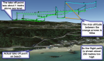
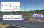
When I move a flight over to Google Earth via FlightData Manager the path of the flight is showing up high above the actual altitude of the flight. Maybe it is easier to say that if, for example, the path is at 10 metres above the surface, it shows up in Google Earth around 30 metres or so. A few months ago it was working correctly.
At first I thought I had changed the settings in Google Earth so that the vertical scale was too great, but that doesn't seem to be the case.
Has Google Earth changed or has FlightData Manager a known problem? Or, and probably most likely, am I doing something wrong?
Regards
Douglas
 
Douglas,
Have you tried emailing the creator of FlightData Manager? I had a problem once with flights not appearing and he was very helpful and responded within a day.
 
I finally got round to contacting the creator about a week ago - No reply (so far)
Regards
Douglas

PS. What other suggestions do you have for an application to show the flights on Google Earth/Maps?
 
I just read your starting post again.
about 3 times higher: could it be a measure ("feet - meter") problem?
Thank you for the suggestion Dirk. I will take another look at the problem later. I have one flight where I was 1 to 2 metres over the surface of the sea. I seem to remember it showed up looking like it was 10-15 metres. I also thought that the vertical scale for Google Earth might be set to too high a number. I will check that out again. I'll post my observations after I have a chance to check these points.
Regards
Douglas
 
Here I am back again Dirk.
I checked 3 different flights at random. The earliest one shows correctly in GoogleEarth. The other 2 (most recent about 2 weeks ago) show up with the problem I have noticed. By the way, I do not use the Google Earth function so often, so this is not ba show stopper for me.
I will attach the 3 screen shots with some notes.
Regards
Douglas
 

Attachments

  • wrong height 2 GE.png
    wrong height 2 GE.png
    1.1 MB · Views: 23
  • correct height GE.png
    correct height GE.png
    407.9 KB · Views: 24
  • wrong height GE.png
    wrong height GE.png
    686.8 KB · Views: 20
Douglas
I took a flight from yesterday that I had a RTH flight path. RTH was set at 150 feet ALT. Flightdata Manager confirmed it to be 150.9 feet. When open in Google Earth it shows as 209 feet ALT.
I now wonder why the difference also. 1849
 
Yesterday I was out flying and FDM showed the altitudes of the flight correctly in Google Map.
I have a wild theory.
I do not always remember to calibrate the drone before a flight.
I did calibrate it yesterday before flying. I was pretty close to sea level then.
If had not calibrated it yesterday, and my previous calibration had been done on a mountainside would that affect the altitude of yesterday's Anafi flight on GoogleMaps?
Would Anafi be remembering the last calibrated flight's altitude as being the zero altitude point?
If this is possible then the solution would be to always calibrate the Anafi before flights starting from different heights above sea level.
Just a wild theory!
Regards
Douglas
 

New Posts

Members online

No members online now.

Forum statistics

Threads
5,295
Messages
45,053
Members
7,965
Latest member
Peanut