Well I have put the word out on facebook to see if we can draw some new folks into this with crashed JSON files to help give some much needed info. I also asked a member I know had a unexplained drop from the sky some time back to post his .JSON file for you guys so hopefully we will start seeing some more information coming in.

Welcome to our Community
Wanting to join the rest of our members? Feel free to sign up today.
Sign up

You are using an out of date browser. It may not display this or other websites correctly.
You should upgrade or use an alternative browser.
You should upgrade or use an alternative browser.
Show Anafi Log Project
- Thread starter Jagerbomb52
- Start date
RemE
Well-known member
- Joined
- Nov 27, 2018
- Messages
- 62
- Reaction score
- 32

Whilst some are self explanatery such as 3 - critical battry, 4 - low battery and 5 - excessive tilt we do not know the actual values that triiger them e.g. how low does a battery have to be to trigger the critical alarm and what tilt will trigger the excessive tilt alarm
I've looked at a couple of 'grab and tilt landings' I've done and the cutoff angle seems to be 90 degrees, i.e. pi/2 radians in the file.
Liger 1956
Well-known member
If any members would like to share files then probably the best way is to upload it to cloud storage and let myself and h-elsner know the link by starting a conversation with us.
RemE
Well-known member
- Joined
- Nov 27, 2018
- Messages
- 62
- Reaction score
- 32
Done!If any members would like to share files then probably the best way is to upload it to cloud storage and let myself and h-elsner know the link by starting a conversation with us.
It will be interesting to see is anything new comes from this. When mine dropped, I had been cruising back closer to home. I had stopped and was beginning to move slowly forward, framing a shot to take some pictures. Battery at 40%, no wind, no obstacles, no fast movements. I saw a message "landing" (but it was approx. 60M high), then the video showed tumbling, then lost signal. This all happened in a few seconds.
Last edited:

Liger 1956
Well-known member
RemE,
I have had a quick look at your JSON file and the flight_state at the start of the file is 6 and not 7 as we normally see. This could be because it is the oldest file that I have seen and Parrot may have changed the parameter numbers. I think that we can still assume that a value of 6 still means that the Anafi is arming the motors prior to take off.
Unfortunately the log appears to end before the Anafi tumbles back to the ground. The flight looks normal up until the end of the log although there is no landing phase. The last entry gives a vertical speed of 0.053 ft/s (or m/s if you were using metric units at the time) which is nearly zero, and the maximum tilt angle during the whole of the flight is about 25 degrees with no signs that I can see at first glance of any problems. The altitude towards the end of the flight is a fairly constant 40 above take off. As you say it was at 60m I am a bit confused as to the units involved. Did you use imperial or metric for the flight? There is no sign of it dropping like a stone or tumbling. There is also no alert_state recorded which would lead me to assume a complete shutdown of the Anafi during flight meaning that no more data could be added to the log and the motors would stop.
Do you think that is a fair assumption?
RemE
Well-known member
- Joined
- Nov 27, 2018
- Messages
- 62
- Reaction score
- 32
RemE,
I have had a quick look at your JSON file and the flight_state at the start of the file is 6 and not 7 as we normally see. This could be because it is the oldest file that I have seen and Parrot may have changed the parameter numbers. I think that we can still assume that a value of 6 still means that the Anafi is arming the motors prior to take off.
Unfortunately the log appears to end before the Anafi tumbles back to the ground. The flight looks normal up until the end of the log although there is no landing phase. The last entry gives a vertical speed of 0.053 ft/s (or m/s if you were using metric units at the time) which is nearly zero, and the maximum tilt angle during the whole of the flight is about 25 degrees with no signs that I can see at first glance of any problems. The altitude towards the end of the flight is a fairly constant 40 above take off. As you say it was at 60m I am a bit confused as to the units involved. Did you use imperial or metric for the flight? There is no sign of it dropping like a stone or tumbling. There is also no alert_state recorded which would lead me to assume a complete shutdown of the Anafi during flight meaning that no more data could be added to the log and the motors would stop.
Do you think that is a fair assumption?
Yes, that's a fair report. Regarding height, I was flying out of my back yard which is on a hillside overlooking a school and park. The model's reported alt was about 40M above takeoff, but the crash site was at the school below, so the model's height AGL was about 60M. Yes, I believe it shut down/rebooted etc. and just fell, I did see about 1-2 revolutions of tumble on my phone video before impact but the logs stopped pretty much just before the drop. I suspect that the impact and power loss slightly corrupted the log file, much like video files lose the last few seconds if a model is powered off while recording video. Just my guess. I still wonder about the brief "Landing" message just before the drop, no reason at all for that to have been displayed.
h-elsner
Well-known member
- Joined
- Jan 20, 2019
- Messages
- 131
- Reaction score
- 171
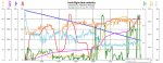
Today's version is out. The additional window with chart or counters table is working. Click on the header of the data table to open the window.
The measurement units are still to be done. Also GPX export is missing. More work for the next days...
But I think now it is worth to test the application with respect to the data and meaning of the values. Anafi owner are now in charge. I'm interseted in measurement units and ENUM values like alert_state. The found meanings of those enum values must now be checked against the reality.
br HE
h-elsner
Well-known member
- Joined
- Jan 20, 2019
- Messages
- 131
- Reaction score
- 171
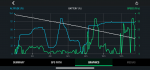
ShowAnafiLog:
Todays version is out. The main functions are all in. Measurement units are still an open issue. I do not know, what units the JSON files deliver. Depends this on the settings of the device or is it always metric or ...
A second functionality is still missing: I want to show a cursor in the second window chart, where you are in the data table.
Windows64bit: http://h-elsner.mooo.com/downloads/ShowAnafiLog.zip
If someone needs a LINUX version please tell me.
br HE
h-elsner
Well-known member
- Joined
- Jan 20, 2019
- Messages
- 131
- Reaction score
- 171
Drag&Drop of a file or directory to the application is now working.
Ross
Well-known member
- Joined
- Dec 1, 2018
- Messages
- 79
- Reaction score
- 19
ShowAnafiLog:
Todays version is out. The main functions are all in. Measurement units are still an open issue. I do not know, what units the JSON files deliver. Depends this on the settings of the device or is it always metric or ...
A second functionality is still missing: I want to show a cursor in the second window chart, where you are in the data table.
Windows64bit: http://h-elsner.mooo.com/downloads/ShowAnafiLog.zip
If someone needs a LINUX version please tell me.
br HE
Thanks a lot for the great work. I work on OSX (MacBook Pro), is it possible to have a software compatible with OSX? I know I can run a software on my macbook to read windows but I don't like to work like that.
Rgds,
h-elsner
Well-known member
- Joined
- Jan 20, 2019
- Messages
- 131
- Reaction score
- 171
I work with a multi-platform IDE (Lazarus+Free Pascal) which can complie native applications for Windows, LINUX (RaspBerry PI too) and MAC OS X (and some more) from the same source code.
The problem is, I have no MAC to complie and test. The only machines that I have here are Windows 32/64 bit, LINUX on x86 32/64bit and Raspberry PI.
Sorry, MAC version is not planned this time.
br HE
The problem is, I have no MAC to complie and test. The only machines that I have here are Windows 32/64 bit, LINUX on x86 32/64bit and Raspberry PI.
Sorry, MAC version is not planned this time.
br HE
h-elsner
Well-known member
- Joined
- Jan 20, 2019
- Messages
- 131
- Reaction score
- 171
New version V0.5 is available on the server
http://h-elsner.mooo.com/downloads/ShowAnafiLog.zip
Now all features are in. Measurement units conversion is working, cursor in 2nd chart too.
My assumption is that Anafi delivers all data in metric in the JSON file. because I do not own an Anafi I cannot do proper tests. Now it is up to you, doing tests for identifying enum values, checking measurement units, directions, altitude and so on against reality.
Please help to find bugs.
br HE
Just something I made up in photoshop. Maybe someone has some better ones.


Dirk_ANAFI
Well-known member

With the latest version, the Altitude Axis in the charts tab, the label changes from meters to feet however the numbers remain as meters. The axis on the right of the chart changes correctly between metric and imperial both in labels and numbers.
Using the Details tab, the box labelled statistics always remains metric regardless of selection in the Settings tab.
Thanks for a great piece of software!
Tom
Using the Details tab, the box labelled statistics always remains metric regardless of selection in the Settings tab.
Thanks for a great piece of software!
Tom
