Welcome to our Community
Wanting to join the rest of our members? Feel free to sign up today.
Sign up

Translating Litchi missions to Flight Plan (FF6) missions.

Peio64270

Member
Joined
Sep 22, 2019
Messages
23
Reaction score
13
Hi,
User of DJI drones since 6 years, mostly with waypoint missions built in the Litchi Hub (and since 2 years, with the invaluable help of Virtual Litchi Missions and Google Earth Pro), I first wanted to use my saved Litchi missions with my new Anafi and, second, I felt painful to build new precise and secure missions in my phone, even if displayed in my larger computer screen when using TeamViewer. Thus, I asked a friend of mine --who is familiar with coding-- to design a small program able to translate the Litchi's CSV files to the Parrot's JSON files.

This is done as prototype (for Windows 10) and looks as it is working very well (example below).

If some Parrot's and DJI's pilots are interested in, I can share it in my Dropbox.
Let me know.
 

Attachments

  • savedPlan-CSV.JPG
    savedPlan-CSV.JPG
    110.6 KB · Views: 82
  • savedPlan-JSON.JPG
    savedPlan-JSON.JPG
    166.6 KB · Views: 76
Looks interesting. Have you tested it at all with a flight? No problem sharing a link but please do add a disclaimer that the end user takes all responsibilities for his or her actions.
Looking forward to hearing if it really works.
 
Looks interesting. Have you tested it at all with a flight? No problem sharing a link but please do add a disclaimer that the end user takes all responsibilities for his or her actions.
Looking forward to hearing if it really works.

I'm going to test it next week if the (very bad) weather improves, here.
But no reason it would not work.
 
I'm going to test it next week if the (very bad) weather improves, here.
But no reason it would not work.

Yes one of the members from the Autelpilots forum @Franlic posted the heavy snow they got around his village and the power is still out in some places he said,

 
  • Like
Reactions: dashSolo
Yes one of the members from the Autelpilots forum @Franlic posted the heavy snow they got around his village and the power is still out in some places he said,


:) I am in France close to the Spanish border (Biarritz). Here, we have heavy rain and wind since one month, almost every day. Snow in the Pyrenees mountains, yes.
 
Exactly what I was looking for. Would be really interested in that converter.

Still testing it (and designing the reverse program). It will likely remain some instructions to set manually, such as Litchi's "Crusing Speed" and in Flight Plan, the angular speed of camera pitch changes (10°/s by default) if no "Focus POI" at waypoint...
I'll update when ready...
 
I´m interested in Litchis Height above Ground feature. I´m flying an ANAFI Thermal, using it to look for Fawn (Baby Roe) in meadows, before they get mown.
Since the really crappy resolution of ANAFI´s Thermal Camera, it is vital to maintain height over ground. Terrain Changes here permanently, so even if you fly at 30m above Starting Point, you may be 10m or 50m above Ground. Too high, and you miss something because of low resolution, too low, and you miss something because of narrow field of view.
To get Height above ground in FF6, the only way is to work with Google Earth and get Terrain Height of each and every Flight Point, and calculate "height" manually.... Very easy to make a mistake. So beeing able to use Litchi instead would be of grat benefit. Also because of the Ability to program with the Ergonomics of a PC Mouse....
Reaaly looking forward to this !

Yes, I understand. I have not tested yet with this setting (above ground) but no reason it doesn't work.
Right now, everything works except gimbal pitch which uses a different procedure in FlightPlan (gimbal pitch set at a waypoint is the pitch you get AFTER this waypoint at a distance depending on the angular speed you chose in °/sec.). Thus, in the JSON file the pitch has to be set one waypoint in advance compared to the CSV file from the Hub.
 
I´m interested in Litchis Height above Ground feature. I´m flying an ANAFI Thermal, using it to look for Fawn (Baby Roe) in meadows, before they get mown.
Since the really crappy resolution of ANAFI´s Thermal Camera, it is vital to maintain height over ground. Terrain Changes here permanently, so even if you fly at 30m above Starting Point, you may be 10m or 50m above Ground. Too high, and you miss something because of low resolution, too low, and you miss something because of narrow field of view.
To get Height above ground in FF6, the only way is to work with Google Earth and get Terrain Height of each and every Flight Point, and calculate "height" manually.... Very easy to make a mistake. So beeing able to use Litchi instead would be of grat benefit. Also because of the Ability to program with the Ergonomics of a PC Mouse....
Reaaly looking forward to this !

Unfortunately it will not be possible to report automatically "above ground" altitudes in the ".json" files which are used by Flight Plan because the ".csv" file which is generated by Litchi hub and which is used by our small program for building the Flight Plan mission does not contain these data. This Excel file only contains a column with raw altitudes and an other column specifyng how this altitude has to be interpreted by the app. This column defines an "Altitude mode" that can be 0 (raw altitude is used) or 1 (altitude above ground elevation is used).
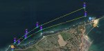
However, our little app can help to edit Flight Plan waypoints to set them at "above ground altitudes" as calculated by Litchi. I have built a short "above ground" mission over an uneven terrain which is my usual playground : Mission Hub - Litchi. All waypoints are set at 40m "above ground".
As usual in the hub altitude at each waypoint is defined as the desired altitude above ground elevation (here 40m) and between brackets, the absolute altitude the drone has to reach to comply with these fixed 40m above ground (for waypoint 5 above the beach, this altitude will be roughly 5 m. In fact, I think that it rather should be 0m because altitude above sea level at waypoint 1 will be roughly 80m, i.e. ground elevation = 40m at this waypoint). The Litchi mission displayed in Google Earth :

1575032728371.png

If, with our little app, I transcript this .csv mission in .json mission for Flight Plan, I obtain this in FF6 :

1575033199904.png
All altitudes are set at 40m and not above ground level but the advantage is that all other settings of my Litchi mission are faithfully reported here (heading, gimbal pitch, speed ...) and specially the position of waypoints which is absolutely identical to the hub one.
Thus, if I trust "above ground" altitudes defined by the Litchi hub, I have just to edit all Flight Plan waypoints for altitude in order to get my complete Anafi mission. This is what I have done below in reporting the bracketted rounded values displayed in the hub :

1575033775570.png

This edition can be done in the app or directly by editing the .json file with a text editor in your PC.

Hope this helps. I'm going to test this this afternoon by compairing the same missions flawn with my Mavic and by Anafi. Crossing fingers :)
 
Thanks for your report, and the time you invested in it.
I didn´t want to believe you, so I checked it... You are absolutely right. Even though the Data (in Brackets) is there, it is not beeing saved to the XML File....
It is beeing written as abolute height to the KML File however....

But even the workaround of manually editing waypoints (in FF6 or .json) is way more precise then my current workaround. So: Still looking forward to it....

In the meantime, I wrote to the Litchi Guys via Facebook, and asked them if they plan on implementing direct .json Output for ANafi. They answered:
"Litchi is designed to work with DJI drones. We will consider adding support for other drone models. "
So there still is light at the end of the tunnel ;)

P.S: Good Luck with your comparison Missions !
 
Last edited:
Looking forward to see your results.
To me the crucial question is availability, the reliability, and accuracy of the maps used for the creation of a sound flightplan. I'm living in Tenerife and flying mainly in the steep rocks of the south of the Island. Google Earth without further reliable topographic input is useless for my work.
Ideally Parrot should provide also a possibility to use a vector map instead of the Google picture.
Less ideal and rather time consuming is what I do now but is has worked so far in mountains 700m above the start point

1.Create a flightplan with all the way points (Google picture) , disregarding the heights
2. Converting the JSON file of the FP into a GPX file (thanks to H. Elsner)
3. Superimposing this GPX file to my map reader. (I'm using LocusPro maps} Here I see for each way point the elevation
4. Based on 3. I enter now the heights:
Desired AGL plus Topographic elevation minus elevation at start of FP.
 
  • Like
Reactions: Peio64270
(...)

In the meantime, I wrote to the Litchi Guys via Facebook, and asked them if they plan on implementing direct .json Output for ANafi. They answered:
"Litchi is designed to work with DJI drones. We will consider adding support for other drone models. "
So there still is light at the end of the tunnel ;)

P.S: Good Luck with your comparison Missions !

One Litchi mission completed and successful with the two drones :)
I am globally satisfied but it remains to compare the two shots. I'll see this tomorrow if the weather is not good enough to test the AGL mission (and also the 360 pano feature of FF6. I had no time to do it before night today.

Concerning Litchi app for Parrot, there is hope but I don't expect this can occur soon. They are too busy with the new drones DJI releases at short time intervals.
 
Looking forward to see your results.
To me the crucial question is availability, the reliability, and accuracy of the maps used for the creation of a sound flightplan. I'm living in Tenerife and flying mainly in the steep rocks of the south of the Island. Google Earth without further reliable topographic input is useless for my work.
Ideally Parrot should provide also a possibility to use a vector map instead of the Google picture.
Less ideal and rather time consuming is what I do now but is has worked so far in mountains 700m above the start point

1.Create a flightplan with all the way points (Google picture) , disregarding the heights
2. Converting the JSON file of the FP into a GPX file (thanks to H. Elsner)
3. Superimposing this GPX file to my map reader. (I'm using LocusPro maps} Here I see for each way point the elevation
4. Based on 3. I enter now the heights:
Desired AGL plus Topographic elevation minus elevation at start of FP.

The Litchi mission and its translation in .json for Flight Plan went pretty well if I except one or two details (but this was only my second fly with the Anafi and I have to forget my DJI reflexes). I am very pleasantly surprised by this small drone, so silent that I didn't ear it coming back to the home point :)

I also fly very frequently in mountain or over deep canyons with my DJI drones and I also use your method with topo maps when necessary. But in most occurrences, a great advantage of the Litchi hub together with VLM app by Namirda is the easy way to fly a virtual mission in Google Earth. You can adjust your settings (speed, altitude, heading, gimbal pitch) very rapidly in your computer by shuttling between VLM and Google Earth. Also, I don't like the size of the icons in Flight Plan. They are huge, making the design very imprecise.
 
I´m interested in Litchis Height above Ground feature. I´m flying an ANAFI Thermal, using it to look for Fawn (Baby Roe) in meadows, before they get mown.
Since the really crappy resolution of ANAFI´s Thermal Camera, it is vital to maintain height over ground. Terrain Changes here permanently, so even if you fly at 30m above Starting Point, you may be 10m or 50m above Ground. Too high, and you miss something because of low resolution, too low, and you miss something because of narrow field of view.
To get Height above ground in FF6, the only way is to work with Google Earth and get Terrain Height of each and every Flight Point, and calculate "height" manually.... Very easy to make a mistake. So beeing able to use Litchi instead would be of grat benefit. Also because of the Ability to program with the Ergonomics of a PC Mouse....
Reaaly looking forward to this !

Glad to tell you that the conversion app (from .CSV Litchi to .JSON Parrot) is tested by your servant with success and that it includes now an AGL version based on Google API. You can see a comparative flight derived from a Litchi mission here :

This is the original Litchi's mission : Mission Hub - Litchi

The AGL feature necessitates you open an account at Google Map APIs (free till 40,000 requests).

If you want to test this Beta version, let me know...
 
  • Like
Reactions: Lufthaken
I already have Google map API.... Wanted to try to develop own app for that height over terrain issue. But it turned out I would need programming skills....?

However, I would be glad to test your beta version.
 
I already have Google map API.... Wanted to try to develop own app for that height over terrain issue. But it turned out I would need programming skills....?

However, I would be glad to test your beta version.

Hi,
This Beta version of CSV2JSON.zip is in my DropBox here : CSV2JSON.zip

I have added a README.txt file that I recommand you to read attentively.
This small program does not need any installation. Just unzip it into a folder you create for example in your desktop.

I recall that it works uniquely with the missions created in the Litchi Hub and exported as .csv files.
For future AGL missions to be played in FlightPlan, DO NOT build a mission "above ground" in the Hub. Just enter the desired altitude above ground at waypoints. CSV2JSON will calculate ASL altitudes needed to fulfill this setting provided you have entered a valid Google API key at the right place. In the same time, it will generate a new CSV file with these altitudes ASL that you can use in the Hub or, better, in VLM in order to control you future flight.

(Don't forget to rename your Litchi's original CSV mission after copy into the CSV2JSON folder before running the program. It has to be "savedPlan.csv" in any case).

Enjoy and let me know if you encounter any problem.
 
Hi and thanks for sharing this. I tried it, but could not get it to work, yet.
It says "GOOGLE KEY incorrecte", even though I used the "copy" funktion in console and pasted it directly after comma.
ANy idea, what could be the problem ?

1576434650637.png
I removed the API limitations at google console. Every Time I try it, the "used" counter goes up one numer, but the error message remains....
 
Last edited:
Hi and thanks for sharing this. I tried it, but could not get it to work, yet.
It says "GOOGLE KEY incorrecte", even though I used the "copy" funktion in console and pasted it directly after comma.
ANy idea, what could be the problem ?

View attachment 3156
I removed the API limitations at google console. Every Time I try it, the "used" counter goes up one numer, but the error message remains....

I can't say like this.
It works flawlessly for me.
Do you have a Messenger (Facebook) account in order I can communicate directly with you ?
Does it work with "Above Ground level = False" ?
 
Hi and thanks for sharing this. I tried it, but could not get it to work, yet.
(...)

I just tried with the CSV2JSON that I shared in my Dropbox.
It works :

1576455563530.png

Did you edit the ConfigCSV2Json.csv with a text editor like Wordpad and saved it as a text?

P.S. Your edited ConfifCSV2JSON.csv would be like this in the Notepad, once you have copied your key :

1576455906452.png
 
Last edited:
  • Like
Reactions: edwardfcy1970

New Posts

Members online

No members online now.

Forum statistics

Threads
5,307
Messages
45,095
Members
7,995
Latest member
droneflyer2024