Welcome to our Community
Wanting to join the rest of our members? Feel free to sign up today.
Sign up

Flight plan for Parrot Anafi online

We have some of the toughest spam and blacklisted filters on this site and his IP does not cause any problems. Even when you run it through Stop Forum Spam there are no flags on his IP.

Go to this page to have your IP removed from the black list. Its a simple matter.

 
Hi @abant,

Thanks so much for your very useful flight plan creation tool!

I wonder if I can make an enhancement request, although I know you are busy right now.

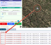
I would like the ability to type in the coordinates of the waypoints directly, e.g. Lat: 37.2149377, Lon: -107.1892491 instead of only being allowed to drag points around on the map. My reasons:
  • I have the exact coordinates already from a previous survey on foot.
  • The map includes sections that are relatively flat and featureless and hard to distinguish from each other using satellite images.

Thanks so much!
 
A couple of changes were made.
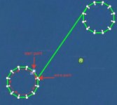
When inserting an orbit with the "Center" orientation, another additional WP is added as a continuation of the orbit, that is, the drone begins a second circle. Thus, if you insert an orbit of 30 points, you will get an orbit of 372 degrees instead of 360 degrees on the flight plan (360+360/30=372).
This extra WP is added for two reasons. First, it ensures that you get photos or videos with overlap, which is very important when creating a panorama. Second, it avoids changing the drone's orientation at the last point of the full 360-degree orbit, when there are other points after the orbit in the flight plan. Example:
2020-11-29_14-44-37.jpg
 
I am a relatively new Anafi owner and finally took some time to use abant's online flight planning tool. Excellent work! Must have taken him considerable time to develop and host this and he's clearly refined it with feedback from this forum. I donated via paypal and encourage others to evaluate the tool and donate as well if they find it useful!
 
  • Like
Reactions: zandoli
I am a relatively new Anafi owner and finally took some time to use abant's online flight planning tool. Excellent work! Must have taken him considerable time to develop and host this and he's clearly refined it with feedback from this forum. I donated via paypal and encourage others to evaluate the tool and donate as well if they find it useful!
I'm glad you like it. And thank you for the donations!
 
thanks ,but I don't see how to add way point in top of another way point , I want to have a vertical mission for towers or building at the same position flying from bottom to the top and in most flight plans they only have 2d and not 3d view
 
Hello what is the link to the flightplan generator? (in English) I want to recreate some plans in it and load in my old and new tablet to test.

I guess there is still no way to extract existing FlightPlans?

Thanks for help
 
Hi abant,
I really like your Flight Plan for Parrot Anafi webpage. It is very easy to use and makes flight planning much more convenient. Thanks for all your hard work on it!

Would you be able to add another option to the photo action. I would like to perform a GPS-Lapse. This would allow the user to specify the desired change in GPS position (distance) between captures.

Thanks,
Ron
Unfortunately, if an action can't be created in FF6, then it can't be loaded in FF6.
 
@abant Thank you for creating this I am just creating a flight plan and am struggling with the rotate option, when I rotate the route the whole thing just disappears, do you have an idea what I am doing wrong

update. Ignore this sorted this out
 
Last edited:
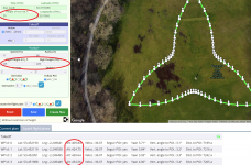
@abant or anybody that can help. I am having trouble selecting and inserting a trefoil, yes I am selecting imperial first, however when I set the height h1 and h2, it is inserting the altitude in metres, it is also doing the same with the orbit.
It is also convert the speed as well as you can see

however, if I insert the orbit first, the orbit is inserted in feet but then if I insert a trefoil after inserting the orbit the trefoil is yet again been inserted in metres.

Is there something obvious I am doing (or not doing )?

2021-06-12 20_32_28-Flight plan for Parrot Anafi - Brave.png
 
Last edited:
Hi Abant, hoping you are doing well and that you can deal with some problems we are facing with the latest Anafi's FW 1.8.2.

We appreciate very much your online tool create and transfer the zip file as before.
We can load and see the plan in FF6 but when we press the play button nothing happens. The drone just hovers there you have lifted it without flying to the first WP. If you create a flight plan in the application the drone executes it.

Here is some info another user of your tool has found about the latest Anafi FW.

"Perhaps of some kind of coding change in the update? (Enhancements to autopilot capabilities)
ANAFI, ANAFI Thermal & ANAFI USA FIRMWARE 1.8.2
DSP stability evolutions (ANAFI USA only)
Greater precision for landing (barometer ground effect)
Enhanced Wi-Fi network security
Enhancements to autopilot capabilities"

May be you could understand better why the flight plans from the online tool are not running in the latest Anafi. Your tool is very handy and we should be thankful to see it working.

BR,
Tasos
 
@abant or anybody that can help. I am having trouble selecting and inserting a trefoil, yes I am selecting imperial first, however when I set the height h1 and h2, it is inserting the altitude in metres, it is also doing the same with the orbit.
It is also convert the speed as well as you can see
however, if I insert the orbit first, the orbit is inserted in feet but then if I insert a trefoil after inserting the orbit the trefoil is yet again been inserted in metres.
Is there something obvious I am doing (or not doing )?
The error has been fixed.
 
  • Like
Reactions: LT Black and BRC

New Posts

Members online

Forum statistics

Threads
5,295
Messages
45,051
Members
7,965
Latest member
Peanut